| WPC Met Watch |
|
|
Mesoscale Precipitation Discussion: #0589 (2022) |
|
(Issued at 1110 PM EDT Mon Jul 25 2022
) |
|
| MPD Selection |
|
|
|
|
|

Mesoscale Precipitation Discussion 0589
NWS Weather Prediction Center College Park MD
1110 PM EDT Mon Jul 25 2022

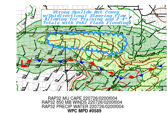
Areas affected...Central MO...Northeast KS...Southwest IL...

Concerning...Heavy rainfall...Flash flooding possible

Valid 260310Z - 260900Z

SUMMARY...Elongated band of WAA convection will be oriented
favorably to mean steering flow for prolonged training.  Narrow
band of 2-4" totals falling upon dry ground conditions pose
possible scattered incidents of flash flooding.

DISCUSSION...GOES-E EIR loop shows convective initiation in
proximity to I-70 with percolating TCu as far west as KC and some
shallow cells just north of St. Louis.  VWP shows increasing
upglide of LLJ over stationary front that exists just north of the
KS/OK border.  7H values of SWly flow are increased to 35kts,
though 85H is delayed and still southerly, at 20kts but is
expected to veer and strengthen to 35kts as well, enhancing
convective strength with advecting higher theta-E air into the
mid-level convergence axis.  TPWs are about 1.9-2" and expected to
tick up to 2.2" increasing moisture flux into individual cells and
eventually the length of the convergence axis from the KC metro
into SW IL.  While updraft strength will be moderate given
slightly lower than ideal MUCAPEs up to 1000 J/kg, the dynamics
should overcome for this broad axis.  In a few hours, 7H flow will
veer and increase depth of mean steering axis to match 6-4H flow
and increase the potential for training.   As such, rates of
1.5"/hr are most likely with occasional spots ticking up to 2"/hr.
 This should result in a narrow axis of 2-4" totals with perhaps
an isolated value up to 5".

Limiting factor will be well below average soil moisture ratios.
NASA SPoRT 0-40cm relative soil moisture ratios are driest along
the I-70 corridor at 5-15%.  Given the average/modest instability
and updraft strength, the rain rates may not be intense enough
even with hard-packed, low-infiltration ground conditions
initially.  Still, given the duration of the training and totals
up to 4" is spots, localized flash flooding is considered
possible.  Obviously, flash flooding would become more likely in
proximity of larger urban centers like KC, St. Louis or even
Columbia... or if the strength of the approaching shortwave over W
KS/W NEB supports stronger upstream WAA/backed low-level ascent
building westward to overlap areas affected by last-evening's
overnight heavy rainfall from Republic to Douglas county where
FFG/soil conditions are much deeper saturated resulting in greater
runoff.

Gallina

ATTN...WFO...EAX...ILX...LSX...SGF...TOP...

ATTN...RFC...MBRFC...NCRFC...NWC...

LAT...LON   39889370 39819117 39648960 39298902 38228974
            38559215 38689363 38959583 39649618 39879561
Last Updated: 1110 PM EDT Mon Jul 25 2022
|


