| WPC Met Watch |
|
|
Mesoscale Precipitation Discussion: #0599 (2024) |
|
(Issued at 505 AM EDT Tue Jul 09 2024
) |
|
| MPD Selection |
|
|
|
|
|

Mesoscale Precipitation Discussion 0599
NWS Weather Prediction Center College Park MD
505 AM EDT Tue Jul 09 2024

Areas affected...Northern AR...Southeast MO...Northwest
TN...Western KY...Southern IL...Southwest IN

Concerning...Heavy rainfall...Flash flooding likely

Valid 090905Z - 091505Z

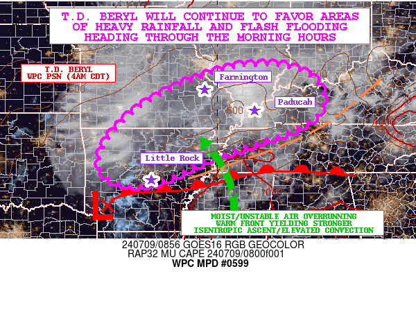
SUMMARY...Tropical Depression Beryl continues to weaken and lift
off to the north-northeast, but will continue to focus additional
areas of heavy rainfall and flash flooding heading through the
morning hours.

DISCUSSION...The very early morning GOES-E GeoColor satellite
imagery shows a generally exposed low-level center that makes up a
weakening T.D. Beryl over far southwest AR just to the
north-northeast of Texarkana. Much of the remaining convection is
situated well off to the northeast of the center in a very
asymmetric manner that is characteristic of a system that is
increasingly becoming extratropical.

Regardless, there continues to be heavy rainfall and flash
flooding concerns, as broken bands of strong convection with heavy
rainfall rates stretch out from central AR northeastward through
northwest TN, western KY and southeast MO. Gradually this activity
will impact more areas of the Lower OH Valley going through the
morning hours including southern IL and southwest IN as Beryl
advances steadily off to the northeast.

MUCAPE values pooled around the eastern flank of Beryl's
circulation center remain on the order of 500 to 1000 J/kg, with a
30 to 40 kt southerly low-level jet overrunning a warm front that
is gradually lifting north through the Mid-South ahead of Beryl's
track. This is resulting in a well-defined southwest to northeast
axis of focused isentropic ascent with moderate to heavy rain and
embedded stronger elevated convective elements. Some of these
convective elements though are focused and show organization given
the level of effective bulk shear (40 to 50+ kts) and updraft
helicity that remains in place.

The 06Z HREF and recent runs of the HRRR guidance suggest
additional heavy rains continuing well through the morning hours
ahead of Beryl, with the dominant focus along and increasingly to
the left of the storm track as Beryl continues to progress to a
baroclinic/extratropical system.

Some rainfall rates with the persistent areas of stronger elevated
convection will continue to be on the order of 1 to 2 inches/hour.
Additional storm totals more regionally going through late this
morning should reach as high as 3 to 5 inches. These additional
rains will continue to favor areas of flash flooding, including
locally more significant urban impacts.

Orrison

ATTN...WFO...ILX...IND...LMK...LSX...LZK...MEG...OHX...PAH...
SGF...TSA...

ATTN...RFC...ABRFC...LMRFC...MBRFC...NCRFC...OHRFC...NWC...

LAT...LON   38608793 38248689 37718648 36928667 36378771
            35878915 35449037 34779178 34589295 34969380
            35499395 36089368 36739316 37369232 38049095
            38548937
Download in GIS format: Shapefile
| KML
Last Updated: 505 AM EDT Tue Jul 09 2024
|


