| WPC Met Watch |
|
|
Mesoscale Precipitation Discussion: #0676 (2024) |
|
(Issued at 1052 PM EDT Sat Jul 20 2024
) |
|
| MPD Selection |
|
|
|
|
|

Mesoscale Precipitation Discussion 0676
NWS Weather Prediction Center College Park MD
1052 PM EDT Sat Jul 20 2024

Areas affected...Southwest Louisiana through Central Alabama

Concerning...Heavy rainfall...Flash flooding possible

Valid 210251Z - 210800Z

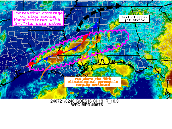
Summary...Thunderstorms will persist and increase in coverage
along a stationary front into the overnight. Rainfall rates of
2-3"/hr are likely, which through slow motion could produce 2-3"
of rain with locally higher amounts. Flash flooding is possible.

Discussion...The regional radar mosaic this evening shows a slow
expansion of higher reflectivity aligned SW to NE from far
southwest Louisiana through central Alabama. This convection is
blossoming within favorable deep layer ascent driven by
convergence along a stationary front analyzed by WPC, modest
isentropic ascent on a weak LLJ emerging from the Gulf of Mexico,
and upper diffluence within the RRQ of an upper jet streak.
Together, this impressive lift is occurring into favorable
thermodynamics characterized by PWs above 2.15", or the 90th
climatological percentile, and MLCAPE of 1000-2000 J/kg.
Radar-estimated rain rates have been 1.5-2"/hr according to KHDC
WSR-88D beneath rapidly cooling cloud tops noted via the GOES-E IR
imagery.

During the next several hours, the 850mb LLJ should at least
subtly intensify from its current 10 kts to 15-20 kts as progged
by the RAP, which will advect even more impressive moisture
northward while driving additional isentropic ascent. Although
subtle backing of the wind may occur in the vicinity of any weak
impulses within the flow aloft, in general the LLJ should veer
into the front to drive impressive moisture confluence, resulting
in a narrow corridor of thunderstorms with intense rainfall rates.
Both the HREF and REFS ensembles indicate a 30-40% chance of 1"/hr
rates, and although the 2"/hr probabilities are just 5-10%, this
is likely underdone as the individual CAMs comprising the
ensembles are generally too low with current coverage and
intensity. The ingredients based approach suggests that the
current activity will persist and may even intensify as
thermodynamics remain impressive in the region of strengthening
ascent. Bulk shear is weak, so strong organization of cells is not
likely, but repeating rounds of heavy rainfall is expected as the
mean 0-6km winds are aligned to the front and to the weak Corfidi
vectors, suggesting training from SW to NE across the area. Where
multiple rounds of storms occur, rainfall could reach 2-3" with
locally higher amounts.

FFG remains elevated across this area except in AL where it is
locally compromised to 1.5-2"/3hrs. Although HREF FFG exceedance
probabilities are modest, the intensity of these rates suggest
rapid runoff is likely, especially in any urban areas or over
locally more saturated soils, which could result in instances of
flash flooding.


Weiss

ATTN...WFO...BMX...JAN...LCH...LIX...MOB...SHV...

ATTN...RFC...LMRFC...SERFC...WGRFC...NWC...

LAT...LON   32898684 32818594 32178615 31748694 31258853
            31088912 30679011 30389090 30039225 29929324
            29949381 30189385 30539365 31569194 32249030
            32408976 32808818
Download in GIS format: Shapefile
| KML
Last Updated: 1052 PM EDT Sat Jul 20 2024
|


