| WPC Met Watch |
|
|
Mesoscale Precipitation Discussion: #0699 (2018) |
|
(Issued at 1037 AM EDT Mon Aug 20 2018
) |
|
| MPD Selection |
|
|
|
|
|

Mesoscale Precipitation Discussion 0699
NWS Weather Prediction Center College Park MD
1037 AM EDT Mon Aug 20 2018

Areas affected...Eastern NE...Central and Northern Iowa

Concerning...Heavy rainfall...Flash flooding possible

Valid 201436Z - 201936Z

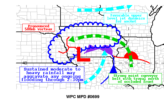
Summary...Persistent moderate to heavy rainfall is likely to
continue into the early afternoon hours in association with a
strong surface low over Iowa.  Flooding issues are possible owing
to the duration of the event, especially for those areas where
there is training of convective cells.

Discussion...An anomalously strong 500mb shortwave and surface low
tracking across Iowa this morning is leading to an enhanced zone
of moderate to heavy rainfall with embedded convective cells.  A
trowal is evident north of the occluded front, with 30 knots of
850mb easterly inflow advecting PWs on the order of 1.75 inches.
Deep layer ascent is being aided by both left dynamics from a
southerly upper level jet max and right entrance dynamics from a
jet max to the north, along with a potent 500mb closed low.  One
of the mitigating factors is the relatively modest values of
elevated CAPE which is helping to keep most rainfall rates under
one inch per hour.  However, rates could exceed this at times
where elevated convection develops.

The latest suite of high res model guidance supports 1 to locally
3 inches of additional rainfall through 1930Z over this region in
association with the trowal.  The lowest flash flood guidance
values currently reside over southwest Iowa and far eastern
Nebraska where the heaviest rainfall thus far has been.  This
could lead to some flooding issues given the persistent nature of
this event.

D. Hamrick

ATTN...WFO...ARX...DMX...DVN...EAX...FSD...GID...MPX...OAX...

ATTN...RFC...MBRFC...NCRFC...

LAT...LON   43699363 43519216 43239133 42689094 42149106
            41829151 41709206 41709274 41659372 41379453
            40819525 40329560 40099620 40289698 40879740
            41759733 42509671 43079609 43519516
Last Updated: 1037 AM EDT Mon Aug 20 2018
|


