| WPC Met Watch |
|
|
Mesoscale Precipitation Discussion: #0781 (2021) |
|
(Issued at 227 AM EDT Sat Aug 14 2021
) |
|
| MPD Selection |
|
|
|
|
|

Mesoscale Precipitation Discussion 781
NWS Weather Prediction Center College Park MD
227 AM EDT Sat Aug 14 2021

Areas affected...South-central AZ...Southeastern CA

Concerning...Heavy rainfall...Flash flooding possible

Valid 140627Z - 141200Z

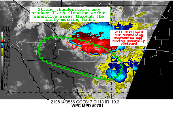
Summary...Widespread thunderstorms are expected through the early
morning hours, and some episodes of flash flooding are possible
where slow moving convective elements develop and produce high
rainfall rates over sensitive terrain through 12Z.

Discussion...Regional Doppler radars are indicating a well
developed MCV over south-central Arizona in response to earlier
convection Friday evening.  This is also evident on GOES-16
infrared satellite imagery with expanding anvil canopies
indicative of robust updrafts capable of producing enhanced
rainfall rates exceeding one inch per hour.  The slowest cell
motions are expected east of the MCV center, and this will include
the greater Phoenix metro area through 8Z.  Flooding is more
likely to occur over existing burn scar locations and dry creek
beds, along with urban areas.

The latest CAM guidance suite is indicating the potential for some
patchy 1-3 inch totals, mainly south of the Interstate 10 corridor
west of Phoenix, and south of Route 70 across southeast Arizona.
Portions of extreme southeast Arizona have already received over 2
inches of rain over the past 24 hours, and any additional rainfall
for those areas would further increase the potential for flooding.


Hamrick

ATTN...WFO...FGZ...PSR...TWC...VEF...

ATTN...RFC...CBRFC...CNRFC...NWC...

LAT...LON   34351416 34291349 33981210 33771146 33401061
            32920976 32280928 31650936 31250990 31221061
            31341134 31641235 31881313 32181416 32421482
            32631535 33171578 33681572 34161544 34311488
Last Updated: 227 AM EDT Sat Aug 14 2021
|


