| WPC Met Watch |
|
|
Mesoscale Precipitation Discussion: #0822 (2021) |
|
(Issued at 1101 AM EDT Wed Aug 18 2021
) |
|
| MPD Selection |
|
|
|
|
|

Mesoscale Precipitation Discussion 0822
NWS Weather Prediction Center College Park MD
1101 AM EDT Wed Aug 18 2021

Areas affected...Pennsylvania, western/central New York State,
western/central Maryland, northern Virginia, DC, far eastern Ohio,

Concerning...Heavy rainfall...Flash flooding likely

Valid 181501Z - 182101Z

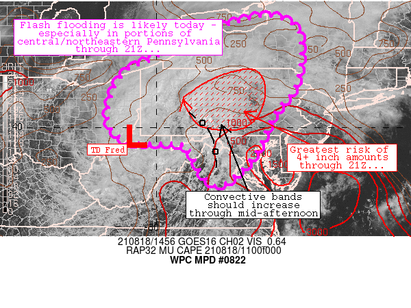
Summary...TD Fred will continue to spread areas of heavy rainfall
across the discussion area today.  Widespread areas of 1-3 inch
rainfall amounts are expected through 21Z, though a few areas in
central PA may experience locally higher amounts.

Discussion...Fred continues its northeastward trek through the
Appalachian Mountains currently.   A couple of axes of heavier
rainfall have been observed with the system: 1) along and just
north of the path of Fred where 1-3 inch rain amounts have been
observed this morning from northwestern West Virginia into
southeastern Ohio and 2) with bands just east of the center (near
AOO in southwestern/south-central PA) that contain deeper
convective elements and heavier rainfall.

As insolation occurs on the southern and eastern periphery of
Fred, concern exists that multiple bands of locally training
convection (moving northward/north-northeastward) will produce
gradually increasing rainfall rates and areas of flash flooding.
Within these bands, 1-3 inch/hr rainfall rates are a more likely
to occur and a few areas could experience 5+ inches where bands
are most persistent.  The greatest risk for this activity will
exist across central PA and appears to be handled generally well
by the 12Z HREF at this time.

A swath of 1-3 inch rainfall amounts is also expected to continue
on the northern periphery of Fred's circulation through 22Z (and
potentially beyond) - generally in northwestern PA into
southwestern New York State.

The aforementioned scenario will likely result in flash flooding
(potentially significant) especially across central and
south-central Pennsylvania today.

Cook

ATTN...WFO...AKQ...ALY...BGM...BUF...CLE...CTP...LWX...PBZ...
PHI...RLX...

ATTN...RFC...MARFC...NERFC...OHRFC...NWC...

LAT...LON   43787616 43347519 42137510 41327531 40697584
            39977622 39207658 38597705 38047778 38237829
            38987871 39437903 39467978 39478050 39448083
            39948154 40758160 41838108 42308015 43027872
            43587719
Last Updated: 1101 AM EDT Wed Aug 18 2021
|


