| WPC Met Watch |
|
|
Mesoscale Precipitation Discussion: #0834 (2023) |
|
(Issued at 535 AM EDT Wed Aug 02 2023
) |
|
| MPD Selection |
|
|
|
|
|

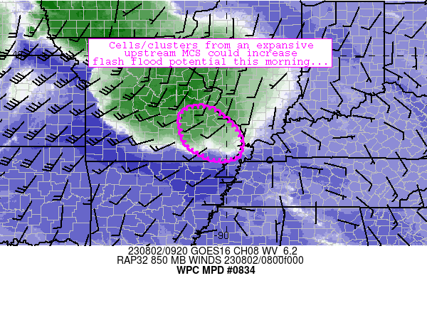
Mesoscale Precipitation Discussion 0834
NWS Weather Prediction Center College Park MD
535 AM EDT Wed Aug 02 2023

Areas affected...southeastern Missouri

Concerning...Heavy rainfall...Flash flooding possible

Valid 020934Z - 021200Z

Summary...A conditional flash flood risk exists across
southeastern Missouri as upstream convection moves toward the
region.

Discussion...An expansive band of convection stretches from
southwestern Iowa through east-central Missouri currently.  The
band has been responsible for radar estimates of 3-8 inches so far
especially across north-central Missouri and 3+ inches of measured
precipitation just east of Jefferson City.  Strong low-level
convergence and abundant moisture/instability was sustaining the
convection, while northwesterly flow aloft (oriented parallel to
the rainfall axis) was allowing for storms to train/repeat.  Flash
flooding remains likely in areas to the northwest of the
discussion area.

Some concern exists that storms will persist while moving
southeastward through the discussion area this morning.  Low-level
flow/convergence (although not quite as pronounced as areas north
and west) persists toward the Missouri Bootheel and should
continue to do so over the next 3-6 hours as the low-level jet
veers toward a more westerly direction over time.  This low-level
flow will also help to maintain 1000+ J/kg MUCAPE and 1.9 inch PW
along the axis of convergence over the next few hours as well.
Current expectations are that 1-2.5 inch/hr rain rates will
materialize and develop southeastward and potentially reach Cape
Girardeau and vicinity.  If these rates can persist beyond 1 hour,
the attendant flash flood risk will increase.

One potential drawback to the flash flood risk is relatively high
FFG thresholds (2.5 inch/hr or greater) partially owing to a lack
of rain in much of the area over the past 7 days.  It'll likely
take at least 1.5 hours of persistent heavier rain rates to cause
excessive runoff (especially outside of sensitive areas).
Furthermore, the conditional nature of persistence of convection
with southeastern extent is also of concern with better
forcing/ascent located northwest of the region.  Flash flooding is
possible in this regime.

Cook

ATTN...WFO...LSX...PAH...SGF...

ATTN...RFC...LMRFC...NCRFC...NWC...

LAT...LON   38289066 38059022 37558970 37088952 36678966
            36619043 37059127 37819152 38149142 38279113
Last Updated: 535 AM EDT Wed Aug 02 2023
|


