| WPC Met Watch |
|
|
Mesoscale Precipitation Discussion: #0835 (2023) |
|
(Issued at 749 AM EDT Wed Aug 02 2023
) |
|
| MPD Selection |
|
|
|
|
|

Mesoscale Precipitation Discussion 0835
NWS Weather Prediction Center College Park MD
749 AM EDT Wed Aug 02 2023

Areas affected...Portions of the Mid-Mississippi Valley

Concerning...Heavy rainfall...Flash flooding likely

Valid 021200Z - 021700Z

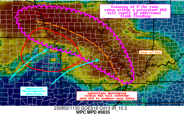
Summary...An impressive MCS will persist this morning before
gradually decaying into the early afternoon. Rainfall rates of
2"/hr will train along this MCS, producing an additional 2-4" of
rain with locally higher amounts possible. Flash flooding is
likely.

Discussion...A linear MCS draped from eastern NE through southeast
MO continues this morning as noted on the regional radar mosaic.
This MCS is continuing to strengthen along its upwind side noted
by cooling cloud tops in the GOES-E IR imagery reaching below
-70C. This convection is being fueled by weak height falls
downstream of a shortwave moving across NE/IA, traversing the
periphery of a mid-level ridge to the south. An impressive 850mb
LLJ of 35-45kts measured via regional VWPs is locally backing in
response, to surge northward intense moisture flux of +2 to +2.5
sigma according to the SREF. The accompanying WAA is helping to
drive additional convective development as thermodynamic advection
occurs beneath 2000-3000 J/kg of MUCAPE and PWs of 1.9-2.1 inches.
This event has already resulted in MRMS measured rainfall of 6-8"
in some areas overnight, and rainfall rates are still 2-2.5"/hr in
deeper convection as estimated by KLSX WSR-88D.

The LLJ which is responsible for most of this activity is likely
to begin to veer to the east and weaken in the next few hours.
However, the upstream shortwave and downstream thickness
diffluence should allow the intensity to maintain through the late
morning. While there is some uncertainty into the placement of the
axis of heaviest rainfall, HREF EAS probabilities for more than 1"
in the next 6 hours are quite high along the nose of this LLJ
where moisture transport vector convergence is maximized. As the
LLJ veers, Corfidi vectors are likely to respond by backing more
to the SW and weakening, suggesting continued backbuilding, with
training from the NW to SE along the MCS also expected. With rain
rates progged by the HREF to exceed 2"/hr at times, this could
result in an axis of 2-4" of rain, with locally higher amounts
possible as reflected by some low end HREF probabilities for 5".

This region has already experienced a corridor of of 2-5" of rain
with local amounts above 6" overnight. This has primed the soils
and compromised FFG to as low as 0.75"/1hr which will likely be
exceeded in the most intense cores as the HRRR shows locally up to
1"/15 minutes. As the LLJ veers the entire system should begin to
weaken and push a bit farther east before decaying, but for the
next several hours flash flooding is likely, especially where
heavy rain returns atop already saturated soils.

Weiss

ATTN...WFO...DMX...DVN...EAX...FSD...GID...ILX...LSX...OAX...
PAH...SGF...TOP...

ATTN...RFC...LMRFC...MBRFC...NCRFC...NWC...

LAT...LON   42269642 42079409 41249183 39869037 38378952
            37478924 36898920 36588936 36768987 36899012
            37589136 38819338 39369528 40269714 41389783
            41979762
Last Updated: 749 AM EDT Wed Aug 02 2023
|


