| WPC Met Watch |
|
|
Mesoscale Precipitation Discussion: #0844 (2023) |
|
(Issued at 218 AM EDT Thu Aug 03 2023
) |
|
| MPD Selection |
|
|
|
|
|

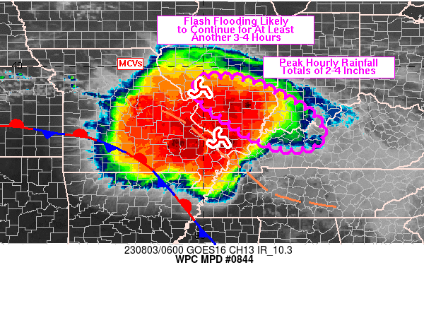
Mesoscale Precipitation Discussion 0844
NWS Weather Prediction Center College Park MD
218 AM EDT Thu Aug 03 2023

Areas affected...south-central IL into southwestern IN/western KY

Concerning...Heavy rainfall...Flash flooding likely

Valid 030616Z - 031015Z

SUMMARY...Training thunderstorms will continue areas of flash
flooding from portions of south-central IL into southwestern IN
and parts of western KY for at least another 3-4 hours. Rainfall
rates of 2 to 3+ in/hr will be likely at times.

DISCUSSION...Training thunderstorms were ongoing over portions of
south-central IL at 06Z with MRMS-derived rainfall rates of 2-4
in/hr in Marion and Clay counties. Within that axis, a recent
local station from Wunderground.com reported 1.84 inches of rain
in 30 minutes, just southwest of Xenia, IL. Needless to say, the
environment is highly capable of producing high rainfall rates
with precipitable water values ranging between 2 and 2.5 inches
along with 500-1500 J/kg MUCAPE (05Z SPC mesoanalysis). The axis
of thunderstorms was occurring northeast of a surface boundary
analyzed in southwestern MO, along an elevated convergence axis
with steering flow quasi-parallel to the convergence axis
supporting training/repeating of cells.

Forcing for ascent is likely to continue ahead of a remnant MCV
analyzed in western IL, and north of a second/newer MCV
propagating through far southern IL, both forecast to continue
advancing to the southeast with the low to mid-level flow.
Thunderstorms are expected to continue forming along the elevated
convergence axis as southwesterly 850 mb winds of 15-30 kt
maintain for another few hours from MO into IL, before some
veering is expected toward the 09/10Z time frame. Peak rainfall
rates of 2-4 in/hr are expected at times within the axis of
training heavy rain with forecast advancement into southwestern IN
and portions of western KY over the next couple of hours.
Redevelopment of convection will remain possible over upstream
regions of southern IL, even as the main ongoing axis of heavy
rain shifts southeastward across the OH River. Flash flooding wil
remain likely over the next few hours and the area will be
monitored for subsequent MPDs around 10Z.

Otto

ATTN...WFO...ILX...IND...LMK...LSX...PAH...

ATTN...RFC...NCRFC...OHRFC...NWC...

LAT...LON   39628963 39508850 38948729 38298628 37578609
            37278694 37538805 38188911 38919007 39549016
Last Updated: 218 AM EDT Thu Aug 03 2023
|


