| WPC Met Watch |
|
|
Mesoscale Precipitation Discussion: #0845 (2023) |
|
(Issued at 310 AM EDT Thu Aug 03 2023
) |
|
| MPD Selection |
|
|
|
|
|

Mesoscale Precipitation Discussion 0845
NWS Weather Prediction Center College Park MD
310 AM EDT Thu Aug 03 2023

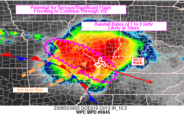
Areas affected...central/southeastern MO into the Lower OH Valley

Concerning...Heavy rainfall...Flash flooding likely

Valid 030708Z - 031030Z

Summary...Training of thunderstorms is likely to continue
producing areas of flash flooding across portions of
central/southeastern MO into the Lower OH Valley through 10Z.
Rainfall rates of 2 to 3 in/hr are expected, although rates
locally in excess of 3 in/hr cannot be ruled out. Given overlap
with recent heavy rainfall, some areas of flash flooding could be
serious/significant.

Discussion...Regional radar imagery at 0630Z showed an axis of
training thunderstorms over east-central MO, from just north of
Jefferson City to near Saint Clair on I-44. This axis has recently
organized over the past hour, about 25-50 miles northeast of an
estimated 3-6 inches of rain which fell since 00Z over parts of
Morgan, Moniteau and Cole counties. While the heavy rain axis to
the south has recently ended, the potential for training will
remain through the morning. Rainfall rates have averaged 1-2
in/hr, but with much of these totals falling in about 30 minutes
and locally above 2 in/hr since 00Z.

WSW 850 mb winds of 20-35 kt were observed on KLSX, KSGF and KPAH
VAD wind plots, with overrunning of a quasi-stationary front in
southwestern MO helping to support the elevated axis of
convection. Mean steering flow oriented parallel to the axis of
elevated convergence will continue over the next several hours per
recent RAP forecasts. However, as a subtle 850 mb low in northern
MO tracks toward the east through 12Z, some strengthening and
veering of low level flow is expected which should have the effect
of translating the axis of heaviest rain toward the south, perhaps
starting around 10Z.

Downstream, an MCV over southern IL was tied to a forward
propagating line of thunderstorms stretching from southern IL into
southeastern MO. As the MCV continues to track toward the ESE,
areas of training heavy rain are likely to maintain in its wake
from portions of southeastern MO across the OH River into western
KY and northwestern TN, supporting an additional flash flood
threat across these downstream areas.

However, the greatest concern for significant/serious flash
flooding will be in central to eastern MO where heavy rain over
the past 48 hours has supported increased water levels on area
rivers and streams along with producing saturated soils. Areas of
flooding are already ongoing in these locations and the addition
of another 2-4 hours of training with rainfall rates possibly
above 2 in/hr will make for a dangerous, life-threatening
situation on the ground.

Otto

ATTN...WFO...EAX...LSX...MEG...OHX...PAH...SGF...

ATTN...RFC...LMRFC...MBRFC...NCRFC...OHRFC...NWC...

LAT...LON   39079258 38659068 38008933 37118812 36348800
            36068861 36228932 36739026 37209105 38089268
            38579324
Last Updated: 310 AM EDT Thu Aug 03 2023
|


