| WPC Met Watch |
|
|
Mesoscale Precipitation Discussion: #0847 (2023) |
|
(Issued at 1100 AM EDT Thu Aug 03 2023
) |
|
| MPD Selection |
|
|
|
|
|

Mesoscale Precipitation Discussion 0847
NWS Weather Prediction Center College Park MD
1100 AM EDT Thu Aug 03 2023

Areas affected...Ozarks through the Tennessee Valley

Concerning...Heavy rainfall...Flash flooding possible

Valid 031459Z - 031800Z

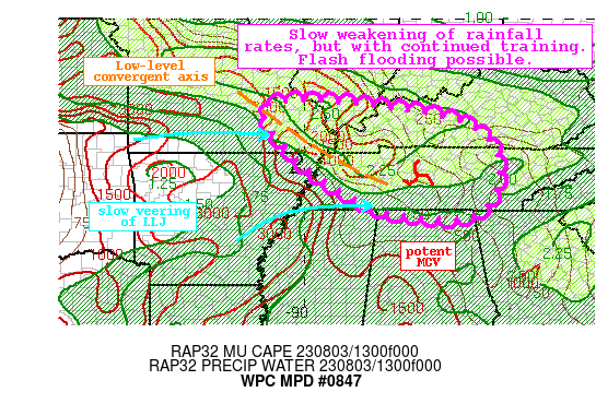
Summary...An MCS dropping southeast out of Missouri will slowly
wane through the afternoon. Rainfall rates of 2"/hr should begin
to weaken, but continued training could result in 2-3" of rain
with locally higher amounts. Flash flooding is possible.

Discussion...The regional radar mosaic this morning shows an
impressive MCS shifting southeast within mid-level NW flow around
a ridge of high pressure to the south. This MCS has shown some
signs of weakening in response to the veering LLJ noted in
regional VWPs, but is maintaining intensity beyond most of the
available high-res. Despite the slow weakening/veering of the LLJ,
forcing is still impressive downstream of a convectively enhanced
shortwave and potent MCV noted in the radar imagery. Southwest of
this MCV, a convergence boundary has developed which is aiding in
low-level ascent on the nose of the 30kt LLJ. This LLJ is helping
to advect robust thermodynamics eastward with PWs above 1.8 inches
collocated with MUCAPE of 3000+ J/Kg. Within this overlap of
forcing and impressive moisture/instability, estimated rain rates
from KPAH have been above 2"/hr resulting in ongoing flash
flooding.

Confidence during the next few hours is less than usual due to
struggles of the high-res models. However, the veering of the LLJ
still advecting intense thermodynamics into the system, a potent
MCV, and at least modest downstream thickness diffluence suggests
this MCS will persist for a few more hours before finally waning.
The HREF indicates that rain intensity will gradually ease noted
by reducing probabilities of 1"/hr and 2"/hr rates, but even as
they weaken, training should allow for rapid accumulations of more
than 0.5"/15 min as reflected by the HRRR. Additionally, upwind
propagation vectors will likely veer more to the SW and collapse
in response to the shifting LLJ, suggesting a continued
backbuilding/training threat along the convergence boundary and
into the higher instability. Where the most impressive training
can occur, 2-3" of rain with locally higher amounts is possible as
shown by HREF probabilities for 3" reaching 20-30%.

Parts of MO/IL/KY and western TN have been saturated recently
noted by AHPS 14-day rainfall that in some areas is more than 200%
of normal and USGS streamflow anomalies around the 90th
percentile. This excludes overnight rainfall which has been
measured by MRMS to be as much as 2-5" in some areas, so some
areas are even more sensitive. Despite the slow reduction of
intensity expected, training atop these sensitive soils or into
any urban areas could still result in instances of flash flooding
through the early aftn.


Weiss

ATTN...WFO...FFC...HUN...LMK...LSX...MEG...MRX...OHX...PAH...

ATTN...RFC...LMRFC...NCRFC...OHRFC...NWC...

LAT...LON   37849004 37778880 37418628 36888524 36198491
            35408505 34928549 34788620 34958781 35558910
            36259012 37269093 37709105
Last Updated: 1100 AM EDT Thu Aug 03 2023
|


