| WPC Met Watch |
|
|
Mesoscale Precipitation Discussion: #0848 (2021) |
|
(Issued at 827 AM EDT Sat Aug 21 2021
) |
|
| MPD Selection |
|
|
|
|
|

Mesoscale Precipitation Discussion 0848
NWS Weather Prediction Center College Park MD
827 AM EDT Sat Aug 21 2021

Areas affected...far southeastern IL into western KY/TN and
northern AL

Concerning...Heavy rainfall...Flash flooding likely

Valid 211226Z - 211735Z

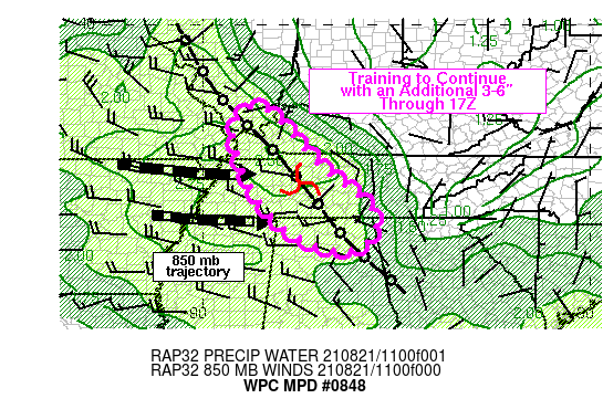
SUMMARY...An axis of heavy thunderstorms will likely continue to
train for at least another 2-4 hours across western KY into
west-central TN. Propagation into northern AL is expected later in
the morning. Flash flooding, which may be fairly significant, is
expected to continue from additional rainfall totals of 3-6 inches
through 17Z.

DISCUSSION...Regional radar imagery at 12Z showed a 10-20 mile
wide axis of training thunderstorms extending from far
southeastern IL into west-central TN. Peak rainfall rates through
12Z were averaging 2.0 to 3.5 inches per hour with reports as high
as 7 inches in 3 hours across southwestern Dickson County ending
at 1130Z. The axis of thunderstorms seemed to be aligned with a
low level axis of convergence which showed up well in the surface
to 850 mb layer of the CIRA Layered PW product. Storms were
forming along the convergence axis with mean movement toward the
southeast, following quasi-parallel to the orientation of upwind
Corfidi vectors.

MLCAPE was estimated to be 1000-1500 J/kg just west of the low
level convergence axis with westerly 850 mb flow noted across the
region, observed to be near 30 kt along the MS River, weakening to
about 20 kt over west-central TN. An MCV was noted ~30 miles
southwest of Nashville, tracking toward the ESE. Low level
convergence is expected to continue in roughly the same location
for another 2-4 hours, but some disruption to the ongoing
organization is expected to occur to the north near the IL/KY
border as upstream outflow nears the region with in the next 1-2
hours. In association with the slowly advancing MCV located
southwest of Nashville, some southeastward progression of the
heavy rain is anticipated, reaching portions of northern AL later
this morning. Overall, an additional 3-6 inches of rain is
expected for portions of western KY into west-central TN,
overlapping with 4-8 inches of rain which has already fallen prior
to 12Z. Additional flash flooding is likely to continue, some of
which could be significant/high-end given the persistent nature of
high rainfall rates.

Otto

ATTN...WFO...BMX...FFC...HUN...MEG...MRX...OHX...PAH...

ATTN...RFC...LMRFC...NCRFC...OHRFC...SERFC...NWC...

LAT...LON   37838867 37718827 37088767 36248691 35728617
            35428588 35068559 34548562 34138643 34738788
            35828877 36728912 37228918 37728902
Last Updated: 827 AM EDT Sat Aug 21 2021
|


