| WPC Met Watch |
|
|
Mesoscale Precipitation Discussion: #0854 (2023) |
|
(Issued at 233 AM EDT Fri Aug 04 2023
) |
|
| MPD Selection |
|
|
|
|
|

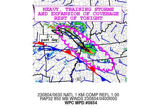
Mesoscale Precipitation Discussion 0854
NWS Weather Prediction Center College Park MD
233 AM EDT Fri Aug 04 2023

Areas affected...Eastern Missouri through northern Alabama

Concerning...Heavy rainfall...Flash flooding likely

Valid 040632Z - 041230Z

SUMMARY...Repeating heavy thunderstorms expected to expand in
coverage from eastern Missouri through northern Alabama rest of
tonight. Reinforcement of ample levels of moisture and instability
should lead to hourly rainfall of 2-3", including over areas of
southeastern Missouri which is vulnerable from heavy rainfall over
the past day. Considerable flash flooding is likely.

DISCUSSION...Mid-level impulses rounding a ridge axis extending up
the middle of the Great Plains has allowed scattered thunderstorm
cluster development in a corridor from eastern MO through
northwest TN since midnight. Hourly rainfall estimates from KPAH
and KOHX have already exceeded 2.5" northwest from Huntingdon, TN
as of 0620Z.

A low level jet of SWly flow from the southern Plains is
reinforcing a pool of high moisture through this corridor with PWs
of 2 to 2.2" (2 sigma above normal). A gradient of increasing
instability from 2000-4000 J/kg of MUCAPE to the southwest is
parallel to both a surface stationary front extending over
Memphis, and the 20kt WNWly deep layer mean flow rounding the
ridge axis. The thunderstorm activity thus far has lined up with
this instability gradient and deep layer mean flow with repeating
activity expected to continue even as it expands both upwind and
downwind.

The ARW is the only recent CAM with a decent depiction compared to
regional NEXRAD and the concept of two main areas, the current one
in NW TN and a second in eastern MO all shifting southeast,
producing an extensive area of 2-4" through much of the discussion
area seems quite reasonable. This is concerning given the overlap
of heavy rain/flash flood LSRs that fell over southeast MO last
night and continued to NW TN yesterday. FFG is generally 1-2"/hr
through this corridor of central MO through western TN. Given the
overlap of forecast heavy rain with prior heavy rain, considerable
flash flooding can be considered likely.

Jackson

ATTN...WFO...BMX...EAX...HUN...LSX...MEG...OHX...PAH...SGF...

ATTN...RFC...LMRFC...MBRFC...NCRFC...OHRFC...SERFC...NWC...

LAT...LON   38919267 38909179 38369029 37588917 36228713
            34458554 33868637 34898867 36689073 37669177
            38539249
Last Updated: 233 AM EDT Fri Aug 04 2023
|


