| WPC Met Watch |
|
|
Mesoscale Precipitation Discussion: #0904 (2019) |
|
(Issued at 1122 AM EDT Fri Sep 27 2019
) |
|
| MPD Selection |
|
|
|
|
|

Mesoscale Precipitation Discussion 0904
NWS Weather Prediction Center College Park MD
1122 AM EDT Fri Sep 27 2019

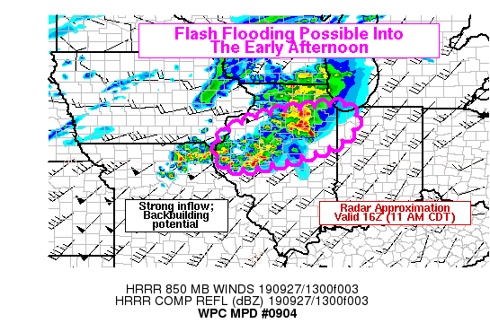
Areas affected...Northern and Central Illinois; Northwest Indiana

Concerning...Heavy rainfall...Flash flooding possible

Valid 271519Z - 271900Z

Summary...A large cluster of thunderstorms has developed over
west-central Illinois. These storms should affect the northern
half of Illinois and northwest Indiana through the early afternoon
with heavy rainfall. The storms may backbuild and affect some
areas for several hours, with flash flooding possible.

Discussion...KILX and KDVN radars showed that a large area of
thunderstorms has gradually become better organized in a region of
confluent low-level flow on the nose of a 50-60 knot LLJ. The
convection was now aligned in larger clusters or bands, all
generally moving to the northeast along the deep layer mean flow
vectors. The strength of the LLJ centered over N MO generally
exceeded the deep layer mean flow (approx. 40 knots), a situation
that favors backbuilding when combined with stronger upstream
instability. Some backbuilding was noted on radar and GOES-16 IR
satellite channels, with cooling cloud tops as far west as IRK in
NC MO. The combination of strong convection, with radar estimated
rainfall rates of 1.0 to 1.5 inches per hour, and backbuilding
should lead to a swath of heavy rainfall across NC IL from 15-19Z.
With 3-hr FFG as low as 1.5 to 2.0 inches across parts of the
outlined area, this scenario could lead to flash flooding if heavy
rain rates can be sustained for a couple hours.

Hi-res models that seem to be performing best relative to current
convective trends include the 12Z runs of the WRF HiRes Windows
(ARW and NMM) and recent runs of the HRRR (12Z and 13Z). These
models generally show a swath of heavy rainfall of 1-3 inches from
Macomb (MQB) to Kankakee (IKK). This seems reasonable, and some
locally higher amounts in excess of 3 inches can't be ruled out,
but the convection still remains somewhat disorganized into
scattered clusters and bands so the heavy rainfall may be more
evenly distributed over a broader area, rather than concentrated
into particular locations prior to 19Z. Therefore, while periods
of heavy rainfall appear likely, flash flooding will be possible
if convective clusters can become oriented sufficiently close to
parallel with the mean flow vectors.

Lamers

ATTN...WFO...DVN...ILX...LOT...LSX...

ATTN...RFC...NCRFC...OHRFC...

LAT...LON   41788728 41228695 40598752 40108901 39819077
            40359135 40979099 41309026 41628904
Last Updated: 1122 AM EDT Fri Sep 27 2019
|


