| WPC Met Watch |
|
|
Mesoscale Precipitation Discussion: #0906 (2019) |
|
(Issued at 657 PM EDT Fri Sep 27 2019
) |
|
| MPD Selection |
|
|
|
|
|

Mesoscale Precipitation Discussion 0906
NWS Weather Prediction Center College Park MD
657 PM EDT Fri Sep 27 2019

Areas affected...Northern and Central Illinois, Far Southeast
iowa, Far Northeast Missouri

Concerning...Heavy rainfall...Flash flooding likely

Valid 272255Z - 280400Z

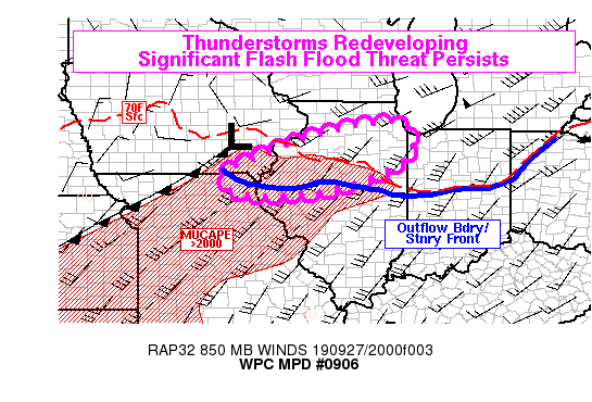
Summary...A new round of thunderstorms is rapidly developing from
northern Missouri into Illinois, with storms expected to become
more numerous into the evening hours. These storms are likely to
produce very heavy rainfall rates, which may exceed 2 inches per
hour in the strongest storms. Additional rainfall between 6 PM and
11 PM local time may exceed 4 inches in some places. That may lead
to significant flash flooding if it falls in areas that received
heavy rain earlier today.

Discussion...GOES-16 IR satellite imagery shows a band of rapidly
cooling cloud tops from VYS-BRL-IRK, extending from NC IL back
into N MO. This was occurring ahead of a surface cold front in N
MO, and to the north of an outflow boundary or reinforced front
stretching across C IL. Regional radars also show convection
gradually becoming more widespread, and aligned close to the mean
flow vectors. With a strong southwesterly low-level jet, strong
instability in the inflow region (MUCAPE generally exceeding 2000
j/kg), and deep moisture (PW values around 1.8 inches per GPS
observations), the ingredients are in place for an extended period
of training convection this evening, particularly in the northern
half of Illinois. Rain rates in this environment could exceed 2
inches per hour, and rain rates that high were observed this
afternoon at PNT. These would easily exceed flash flood guidance
in some spots, as 1hr FFG is as low as 1.0 to 1.5 inches over a
considerable portion of N IL.

The rainfall may be focused slightly further south than the
consensus of hi-res models. HREF means tend to place the highest
21-03Z rainfall amounts near Henry and Bureau Counties in NW IL,
but many of the HREF members seem to (1) overdevelop thunderstorms
in E IA and S WI in a region of weaker instability and then
forward-propagate that to the southeast, and (2) focus initial
development of convection about 50mi north of where it is actually
occurring. Surface observations show a weak mesohigh near PNT, and
this should help reinforce low-level convergence near the outflow
boundary. Therefore, the expectation is that the current broken
line of convection from NE IL into N MO will gradually fill in and
coalesce, leading to a band of training convection on the northern
periphery of the instability axis in the warm sector. The result
should be a 6-hr rainfall maximum by 03Z a little to the south of
the HREF. This would place the heaviest rainfall very close to
areas that received heavy rainfall earlier today, and between
PIA-PNT it was as high as 8 inches based on some storm reports.
The potential overlap of upcoming rainfall with primed ground
conditions raises the concern of significant flash flooding this
evening.

Lamers

ATTN...WFO...DMX...DVN...EAX...ILX...LOT...LSX...

ATTN...RFC...NCRFC...

LAT...LON   41898765 41068752 40328904 40059059 40119203
            40529239 41169114 41798911
Last Updated: 657 PM EDT Fri Sep 27 2019
|


