| WPC Met Watch |
|
|
Mesoscale Precipitation Discussion: #0915 (2018) |
|
(Issued at 442 AM EDT Tue Oct 02 2018
) |
|
| MPD Selection |
|
|
|
|
|

Mesoscale Precipitation Discussion 0915
NWS Weather Prediction Center College Park MD
442 AM EDT Tue Oct 02 2018

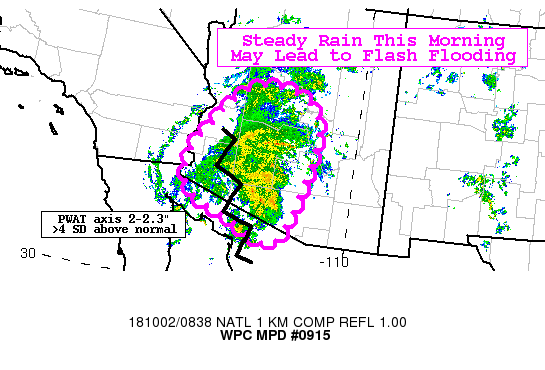
Areas affected...Southern and Central Arizona

Concerning...Heavy rainfall...Flash flooding possible

Valid 020841Z - 021441Z

Summary...Steady moderate to occasionally heavy rainfall from Rosa
pose a localized flash flood threat across the region through the
morning hours. Rainfall totals of 1 to locally 2 inches will be
possible.

Discussion...Recent 1 minute IR imagery from GOES-East mesoscale
sector over Arizona shows a slight uptick in convection and
cooling cloud tops. This is supported by KYUX and KIWA radar
returns where reflectivity has increased in the last 30 minutes
with 1-hr rates between 0.5-1.0".

The latest mesoanalysis shows SBCAPE of 1000-1500 J/kg still
pooled across portions of southern Arizona with little to no CIN
in place as well. This aligns with the PWAT axis of 2-2.3" which
is a very impressive 4-4.5 SD above normal. Fueled by steady
moisture transport in the low-mid levels ahead of Rosa along with
favorable upper level divergence will keep plenty of lift in the
area through the morning hours.

Hi-res models have struggled capturing a lot of the activity and
its northward movement over the past 3-6 hours, but still depict
clusters of heavier showers across southern into south central
Arizona through the morning. With limited (but still present
instability) convection will be more steady/moderate but some
localized intense rates will be possible.

Given what has already fallen across extreme southern Arizona, the
steady rain occurring and to come over areas with low FFG,
localized flash flooding will be possible.

Taylor

ATTN...WFO...FGZ...PSR...TWC...VEF...

ATTN...RFC...CBRFC...

LAT...LON   34791306 34481133 33151122 31301189 31491287
            31791351 32001412 32321454 33231451
Last Updated: 442 AM EDT Tue Oct 02 2018
|


