Skip Navigation Links weather.gov 
NOAA logo - Click to go to the NOAA homepage National Weather Service   NWS logo - Click to go to the NWS homepage
The Weather Prediction Center


Follow the Weather Prediction Center on Facebook Follow the Weather Prediction Center on Twitter
NCEP Quarterly Newsletter
WPC Home
Analyses and Forecasts
   National High & Low
   WPC Discussions
   Surface Analysis
   Days ½-2½ CONUS
   Days 3-7 CONUS
   Days 4-8 Alaska
   QPF
   PQPF
   Flood Outlook
   Winter Weather
   Storm Summaries
   Heat Index
   Tropical Products
   Daily Weather Map
   GIS Products
Current Watches/
Warnings

Satellite and Radar Imagery
  GOES-East Satellite
  GOES-West Satellite
  National Radar
Product Archive
WPC Verification
   QPF
   Medium Range
   Model Diagnostics
   Event Reviews
   Winter Weather
International Desks
Development and Training
   Development
WPC Overview
   About the WPC
   Staff
   WPC History
   Other Sites
   FAQs
Meteorological Calculators
Contact Us
   About Our Site
 
USA.gov is the U.S. Government's official web portal to all federal, state, and local government web resources and services.
 
WPC Met Watch

 
Mesoscale Precipitation Discussion: #0920 (2018)
(Issued at 953 PM EDT Tue Oct 02 2018 )

MPD Selection


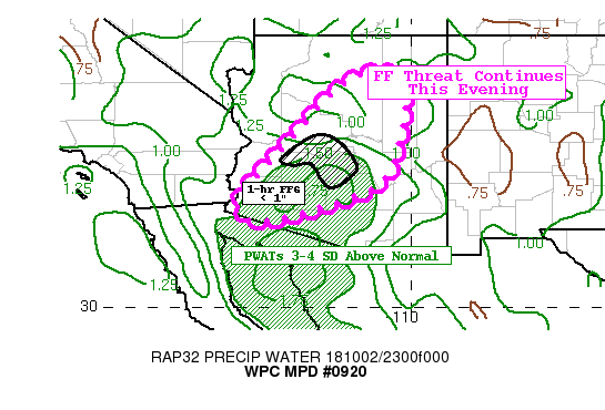
Graphic for MPD #0920

Mesoscale Precipitation Discussion 0920
NWS Weather Prediction Center College Park MD
953 PM EDT Tue Oct 02 2018

Areas affected...Central and Southern AZ

Concerning...Heavy rainfall...Flash flooding likely

Valid 030153Z - 030753Z

Summary...Persistent showers and storms in a highly anomalous
moist environment will likely lead to localized flash flooding
this evening.

Discussion...Localized intense rainfall over portions of southern
into central Arizona will be likely through the evening hours.
Recent observations in the PHX metro (Deer Valley) area indicated
1" in around 30 minutes which lines up well with KIWA radar.

Much of this convection is occurring on the gradient of the high
PWATs (1.5 to 1.7") which is roughly 3-4 SD above normal. A
mesoanalysis shows there is still plenty of SBCAPE (1500-2000
J/kg) to support deeper convection. Hi-res models suggest that
convection will slowly drift north/northeast this evening over
highly sensitive urban areas of PHX and also low FFG areas due to
recent heavy rainfall the past 2-3 days. As a result, localized
flash flooding is likely.

Taylor

ATTN...WFO...FGZ...PSR...TWC...

ATTN...RFC...CBRFC...

LAT...LON   36051099 35831021 34201032 33051104 32231392
            32851440 34021333 35601192


Last Updated: 953 PM EDT Tue Oct 02 2018
 

NOAA/ National Weather Service
National Centers for Environmental Prediction
Weather Prediction Center
5830 University Research Court
College Park, Maryland 20740
Weather Prediction Center Web Team
Disclaimer
Credits
Glossary
Privacy Policy
About Us
Career Opportunities
Page last modified: Thursday, 12-May-2022 19:44:52 GMT