| WPC Met Watch |
|
|
Mesoscale Precipitation Discussion: #0947 (2024) |
|
(Issued at 740 PM EDT Thu Aug 29 2024
) |
|
| MPD Selection |
|
|
|
|
|

Mesoscale Precipitation Discussion 0947
NWS Weather Prediction Center College Park MD
740 PM EDT Thu Aug 29 2024

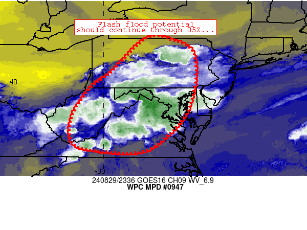
Areas affected...portions of Pennsylvania, Maryland, Washington
DC, Virginia, and West Virginia

Concerning...Heavy rainfall...Flash flooding likely

Valid 292339Z - 300539Z

Summary...Flash flood potential continues for several more hours
(through 05Z).

Discussion...As anticipated, scattered thunderstorms have
developed across the discussion area, with multiple spots of 1-2.5
inch/hr rain rates noted (highest across northern Virginia).  Weak
wind fields through the low to mid-levels has enabled slow and at
times erratic cell movement along with several cell mergers.  The
mergers, along with strong instability (2000+ J/kg MLCAPE) and
very high moisture content (~2 inch PW values) have fostered
intense updrafts with efficient rain rates. A weak mid-level wave
over the OH/WV border region is also aiding in ascent as
relatively cool air aloft migrates slowly eastward across the
region.

The ongoing scenario is expected to continue for several more
hours despite a gradual loss of heating/surface-based instability.
 Mature cold pools will continue to expand across the discussion
area, while weak/negligible convective inhibition continues to
promote new updrafts especially where convection/heavier rainfall
has not occurred.  Spots of 1-2.5 inch/hr rain rates are expected
to continue in this regime.  These rates should continue exceed
local FFGs - especially in urbanized and low-lying areas.
Furthermore, storm motions will continue to remain slow/erratic
and driven by cold pool propagation - especially south of the
Maryland/Pennsylvania state line where steering flow aloft is the
weakest.

Cook

ATTN...WFO...AKQ...BGM...CTP...LWX...PBZ...PHI...RLX...RNK...

ATTN...RFC...MARFC...NERFC...OHRFC...SERFC...NWC...

LAT...LON   41987805 41887682 41417596 40207582 38827613
            37747690 36827832 36948077 37338147 38418144
            39698061 40457963
Download in GIS format: Shapefile
| KML
Last Updated: 740 PM EDT Thu Aug 29 2024
|


