| WPC Met Watch |
|
|
Mesoscale Precipitation Discussion: #0988 (2022) |
|
(Issued at 156 PM EDT Mon Sep 12 2022
) |
|
| MPD Selection |
|
|
|
|
|

Mesoscale Precipitation Discussion 0988
NWS Weather Prediction Center College Park MD
156 PM EDT Mon Sep 12 2022

Areas affected...Mid-Atlantic States including I-95 from
Washington, D.C. to Philadelphia

Concerning...Heavy rainfall...Flash flooding possible

Valid 121800Z - 130000Z

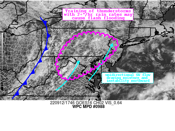
Summary...Showers and thunderstorms will increase in coverage
across the Mid-Atlantic states this afternoon ahead of a cold
front. Rainfall rates at times will exceed 2"/hr, which through
training could produce locally more than 3" of rain. Flash
flooding is possible.

Discussion...The GOES-E visible imagery this aftn shows bubbling
Cu along and ahead of a cold front which is both clearly evident
in satellite imagery and analyzed by WPC moving across WV/eastern
KY. Beneath some of the deeper Cu/TCu, the regional radar mosaic
indicates increasing showers and thunderstorms entering VA, some
of which have radar-estimated rain rates of 1-1.5"/hr. These
storms are developing within favorable thermodynamics
characterized by PWs of 1.6-1.8 inches measured by GPS, and SPC
RAP analyzed SBCAPE of 1500-2000 J/kg. Forcing for ascent is being
provided by convergence along a pre-frontal trough, but also
through impressive mid-level divergence downstream of a closed
mid-level low across the Great Lakes, and increasing upper
diffluence within the RRQ of a poleward arcing and intensifying
jet streak.

The pronounced deep layer ascent will continue to expand to the
east, driving additional convection through the aftn. As this
begins to overlap with even more impressive thermodynamics as
moisture and instability are drawn northward on 850mb flow of
10-20 kts, it will result in both an expansion of convective
coverage, as well an increase in rainfall intensity. The HREF
neighborhood probabilities indicate the chances for 2"/hr rainfall
increasing to 25% later this aftn, while the HRRR sub-hourly
product suggests locally 0.75-1" of rainfall could fall in 15
minutes, implying rainfall rates of more than 3"/hr. Individual
storm motions will likely remain quick on 0-6km mean winds of
20-25 kts, but aligned propagation vectors suggest an increased
risk for training with storms building back into the greater
instability and then lifting northeastward. This will likely
result in 1-2" of rainfall in many locations, with isolated maxima
of 3" or more possible.

14-day rainfall along and west of I-95 has been generally 150-300%
of normal, producing 0-40cm soil moisture that is in the 90-95th
percentile according to NASA SPoRT. This has also produced 3-hr
FFG that is as low as 1.5 inches in some areas, for which the HREF
indicates has a 30-40% chance of exceedance. The most likely area
for flash flooding today will be where any training occurs atop
the most saturated soils, or within any of the more impermeable
areas including the I-95 urban corridor. Flash flooding is
possible this aftn and into this evening, before instability
begins to wane and drier air advects east with the cold front.


Weiss

ATTN...WFO...AKQ...BGM...CTP...LWX...PBZ...PHI...

ATTN...RFC...MARFC...OHRFC...NWC...

LAT...LON   41567667 41407564 41137490 40827449 40577458
            40057497 39397563 38887642 38377723 38027830
            38097877 38367898 38867916 39307924 39907893
            40467860 40957816 41367754
Last Updated: 156 PM EDT Mon Sep 12 2022
|


