|
|
 |
 |
||
 |
| Site Map | News | Organization |
| DOC | NOAA | NWS | NCEP Centers: | AWC | CPC | EMC | NCO | NHC | OPC | SPC | SWPC | WPC |
|
|
|
|
|
||
|
| Site Map | News | Organization |
| DOC | NOAA | NWS | NCEP Centers: | AWC | CPC | EMC | NCO | NHC | OPC | SPC | SWPC | WPC |
|
WPC Medium Range Archive
Medium Range Products Valid On:
10/25/2025
(Day 7 PMDEPD: Valid 10/21/2025 to 10/25/2025)
Extended Forecast Discussion
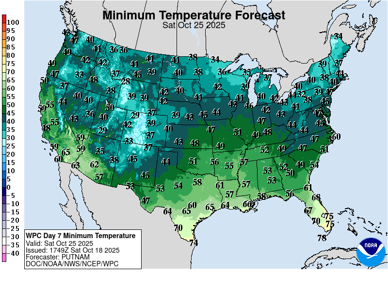
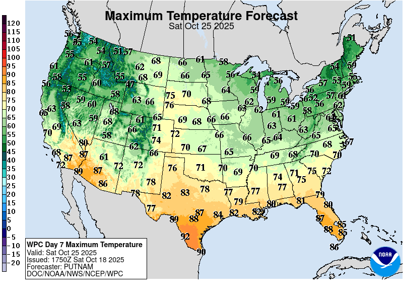
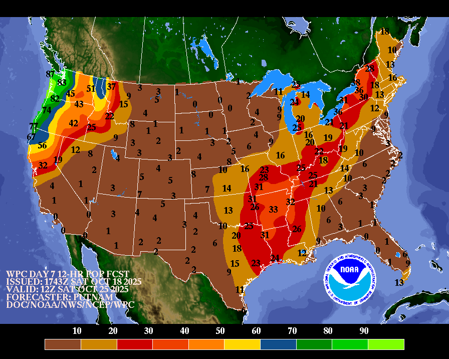
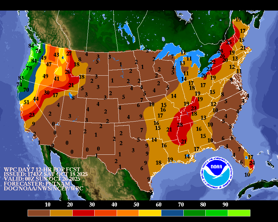
NWS Weather Prediction Center College Park MD 307 PM EDT Sat Oct 18 2025 Valid 12Z Tue Oct 21 2025 - 12Z Sat Oct 25 2025 ...General Overview... A well developed closed low over the Great Lakes on Tuesday will sustain an occluded surface low with a cold front that will cross the eastern U.S. and exit the coast by late Wednesday, with a return to cooler conditions to close out the week as Canadian high pressure settles into the region. Meanwhile, a closed upper low initially off the coast of California moves inland across the southern Rockies and evolves into an upper trough in the southern stream to support a surface low over the Plains with rainfall, possibly heavy, spreading across the south-central U.S. A stronger storm system is likely to approach the Pacific Northwest Thursday into Friday with a potential atmospheric river ahead of a strong cold front, bringing widespread rain and mountain snow. ...Guidance/Predictability Assessment... Updated guidance continues to show a quasi-zonal and progressive pattern heading into early next week. The 00Z ECMWF/CMC/UKMET and 00/06Z GFS are generally agreeable on the broader details, with an initial upper-trough lifting north over the Northeast followed quickly by a second upper-trough and developing closed low settling in over the Great Lakes region. Guidance is also agreeable that the pattern will begin to amplify mid- to late next week as this developing closed low expands over the eastern U.S. and an upper- ridge builds north over the western to central northern tier of the country. Guidance has also come into better agreement on the presence and timing of a southern stream upper-low just off the Pacific Coast moving east over the southwest to south-central U.S. under the upper-ridge mid- to late next week. Guidance begins to diverge a bit with an energetic upper-trough upstream of the amplifying ridge over the northeastern Pacific and the timing of inividial associated shortwaves/surface systems. However, all guidance at least agrees in one particularly deep surface low and associated atmospheric river impacting the Pacific Northwest/California late next week and into the weekend. Differences are limited to timing/orientation on the greatest moisture and associated precipitation. The CMC is notably more aggressive in bringing additional upstream upper-energy and an associated very strong surface low over the Pacific towards the Pacific Northwest next weekend, while this feature is comparitively much weaker in the other guidance. The updated WPC forecast used a composite blend of the ECMWF/CMC/UKMET/GFS for the first part of the period given good overall agreement. The CMC was removed mid-period and replaced with the ECens and GEFS, increasing to 40% of the blend by the end of the period, as the CMC diverged from the other solutions and typical longer-range differences began to grow witin the determinstic guidance. ...Weather/Hazards Highlights... The closed low over the Great Lakes on Tuesday is likely to result in modest amounts of rainfall, but nothing heavy enough to warrant any risk areas in the excessive rainfall outlook. The progressive pattern with consistent post-frontal northwesterly flow over the warmer Great Lakes will also bring the likelihood of lake effect showers through much of next week. The weather pattern gets more active across the West Coast region going into the Thursday-Friday time period, as an amplifying trough and strong cold front advects copious Pacific moisture towards the coast. This will initially affect the western portions of Washington and Oregon Thursday night, and then northern California going into Friday, with a few inches of rainfall possible for the coastal mountain ranges with a potential atmospheric river affecting the region. Showers and storms also increase in coverage across the south-central U.S. by late week as well in association with the surface low that develops. Guidance has continued to show a signal that some locally heavy rainfall may be possible from the southern Plains to the Lower Mississippi Valley. High temperatures across the south-central U.S. are forecast to remain above average for next week, especially for Texas where highs into the 90s may tie/break a few daily high temperature records. There may be some periods of below average temperatures for the Midwest/Northeast following cold frontal passages, though highs in general look to remain near Fall averages through much of next week. The northern-tier from the Rockies east to the Plains/Upper Midwest will see increasingly above average highs late next week and into the weekend as an upper-ridge builds overhead. The Pacific system will bring cooler, well below average temperatures to portions of the West Coast by early next weekend. Putnam/Hamrick Additional 3-7 Day Hazard information can be found on the WPC medium range hazards outlook chart at: https://www.wpc.ncep.noaa.gov/threats/threats.php WPC medium range 500mb heights, surface systems, weather grids, quantitative precipitation forecast (QPF), excessive rainfall outlook (ERO), winter weather outlook (WWO) probabilities, heat indices, and Key Messages can be accessed from: https://www.wpc.ncep.noaa.gov/medr/5dayfcst500_wbg.gif https://www.wpc.ncep.noaa.gov/medr/5dayfcst_wbg_conus.gif https://www.wpc.ncep.noaa.gov/5km_grids/5km_gridsbody.html https://www.wpc.ncep.noaa.gov/qpf/day4-7.shtml https://www.wpc.ncep.noaa.gov/#page=ero https://www.wpc.ncep.noaa.gov/wwd/pwpf_d47/pwpf_medr.php?day=4 https://www.wpc.ncep.noaa.gov/heat_index.shtml https://www.wpc.ncep.noaa.gov/#page=ovw
|
||||||||||||||||||||||||||||||||||||||||||||||||


