| WPC Met Watch |
|
|
Mesoscale Precipitation Discussion: #0029 (2020) |
|
(Issued at 1008 PM EST Fri Jan 24 2020
) |
|
| MPD Selection |
|
|
|
|
|

Mesoscale Precipitation Discussion 0029
NWS Weather Prediction Center College Park MD
1008 PM EST Fri Jan 24 2020

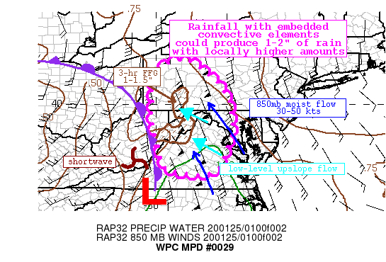
Areas affected...Central VA, Eastern WV, Western PA, Central and
Western MD

Concerning...Heavy rainfall...Flash flooding possible

Valid 250307Z - 250900Z

Summary...An area of moderate rain will continue to lift
north/northeast overnight. Rainfall rates may briefly exceed 1"/hr
in any embedded convective elements. Rainfall totals are expected
to be widespread of 1-1.5", with isolated amounts to 2.5" in the
terrain or where any enhanced training occurs. Localized flash
flooding is possible.

Discussion...Satellite imagery this evening depicts a large closed
low centered over the Ohio Valley, with embedded shortwaves
rotating around. One of these shortwaves is evident in WV imagery
near the WV/VA border, and is aiding in pushing an occluded front
extending from a surface low in NW Ohio to the east. Ahead of this
boundary, robust moist and warm advection is producing an
expansive area of showers with moderate to heavy rain.

00Z U/A soundings from KIAD and KPIT both analyzed PWATs near
0.8", above the 90th percentile for the date, and 1.5-2 standard
deviations above the climatological normal. The soundings also
indicate unidirectional flow from 925mb through 300mb, and 850mb
flow of 30-50 kts, which is forecast by the RAP to rise above 50
kts overnight, also exceeding the 90th percentile for late
January. The combination of this strong flow in a moist
environment will continue the threat for heavy rainfall. Despite a
dearth of instability, deep layer ascent through height falls and
PVA will allow for embedded convective elements which could cause
rainfall rates to rise to 1"/hr at times as shown by recent HREF
neighborhood probabilities. There is also likely to be some
enhanced upslope ascent into the terrain of WV and PA as low-level
flow intensifies due to a sharp pressure gradient between high
pressure over New England and the approaching front/surface wave
from the southwest. Additionally, as the front moves eastward,
layer Corfidi vectors will gradually become more aligned with the
0-6km mean flow, suggesting training will become increasingly
likely.

Recent rainfall across the area has been limited, with 14-day
departures only 25-75% of normal outside of isolated areas in the
terrain. This has led to modestly high FFG of 2-2.5"/3hrs across
most of the MPD threat region, although some locally lower values
are present. This is also reflected by NWM 40cm soil moisture of
less than 75% east of the terrain. All of this suggests that the
threat for flash flooding is low, but high-res guidance suggesting
the potential for rainfall exceeding 2.5" in some places could
lead to isolated flash flooding overnight.

Weiss

ATTN...WFO...AKQ...CLE...CTP...LWX...PBZ...RLX...RNK...

ATTN...RFC...MARFC...OHRFC...SERFC...

LAT...LON   41807888 41717861 41467827 41027768 40747743
            40387718 40027705 39677698 39347694 39007690
            38607702 38127719 37707733 37427748 37217781
            37177813 37177859 37237901 37357945 37497970
            37917981 38487994 39168010 39708017 40298011
            40788013 41317995 41567976 41617963
Last Updated: 1008 PM EST Fri Jan 24 2020
|


