| WPC Met Watch |
|
|
Mesoscale Precipitation Discussion: #0039 (2023) |
|
(Issued at 537 PM EST Wed Jan 11 2023
) |
|
| MPD Selection |
|
|
|
|
|

Mesoscale Precipitation Discussion 0039
NWS Weather Prediction Center College Park MD
537 PM EST Wed Jan 11 2023

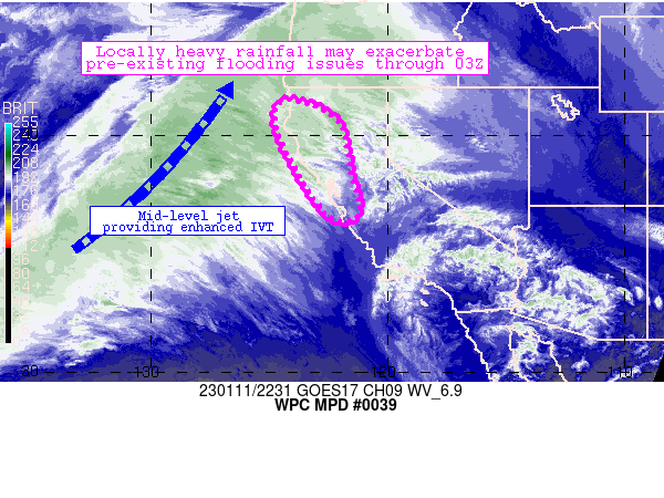
Areas affected...northwestern, central California

Concerning...Heavy rainfall

Valid 112237Z - 120300Z

Summary...Spots of 0.25-0.5 inch/hr rainfall rates should continue
across the discussion area through 03Z or so.  A lessening of
rainfall rates is expected thereafter.  An additional 1-2 inches
of rainfall are possible.

Discussion...As anticipated, a broad fetch of Pacific moisture/IVT
resulted in areas of moderate to locally heavy rainfall across the
discussion area, with rain rates ramping up locally to around 0.5
inch/hr especially after around 18Z or so.  This axis of
lift/moisture will continue to persist across the area for at
least another 4-5 hours or so, with 1-1.2 inch PW values and
onshore mid-level providing lift/ascent for continued convective
development.  These rainfall rates are also continuing atop areas
that have received 10-20+ inches of rainfall in the past 2-2.5
weeks along with widespread flood/flash flood impacts (some of
which are continuing).  The locally heavier rainfall rates could
exacerbate ongoing impacts especially in/near sensitive or already
flooded areas.

Models (CAMs particularly) indicate that the ongoing regime should
continue to produce locally heavy rainfall (and 1-2 inch totals)
through 03Z or so.  Thereafter, backing mid-level flow (in tandem
with a deepening cyclone over northeastern Pacific Waters) will
result in a northward shift of the heaviest of rainfall rates into
far northwestern California and perhaps southern Oregon.

Cook

ATTN...WFO...EKA...HNX...MFR...MTR...STO...

ATTN...RFC...CNRFC...NWC...

LAT...LON   41462399 40552209 38412159 37092123 36472144
            36472237 37542327 39082414 40012461 41072472
Last Updated: 537 PM EST Wed Jan 11 2023
|


