| WPC Met Watch |
|
|
Mesoscale Precipitation Discussion: #0045 (2020) |
|
(Issued at 221 PM EST Mon Feb 10 2020
) |
|
| MPD Selection |
|
|
|
|
|

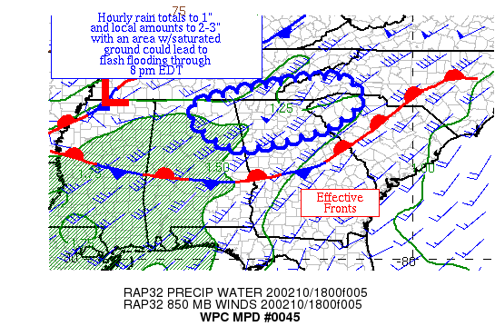
Mesoscale Precipitation Discussion 0045
NWS Weather Prediction Center College Park MD
221 PM EST Mon Feb 10 2020

Areas affected...portions of the interior Southeast

Concerning...Heavy rainfall...Flash flooding possible

Valid 101921Z - 110121Z

Summary...Heavy rainfall is moving into the region from the
west-southwest and is expected to become more convective with
time.  Hourly rain totals to 1" with local amounts of 2-3" are
expected through 8 pm EDT.

Discussion...Moisture is streaming in from the west-southwest
within an atmospheric river moving into the region.  Precipitable
water values are currently 0.8-1.3".  Inflow at 850 hPa is
west-southwest at 30-50 knots per nearby VAD wind profiles,
similar in direction and magnitude to the 850-400 hPa mean wind.
MU CAPE remains under 100 J/kg for much of the area, though trends
are upward across northern AL.  Recent observations show hourly
rain totals of 0.15-0.30", roughly 1/5 of the current precipitable
water value, due to the lack of instability.

With time, hourly rain totals are expected to rise to 0.5-1" as MU
CAPE rises to 500+ J/kg across northeast AL and northern GA and
convective elements become more common within the mostly
stratiform rain areas.  Mesoscale guidance generally advertises
local amounts ~2", but 3" can't be ruled out during the next
several hours.  Two week precipitation anomalies are 150-300%+ of
average, which has led to fairly saturated soils.  Flash flooding
is considered possible through 8 pm EDT.

Roth

ATTN...WFO...BMX...FFC...GSP...HUN...MRX...

ATTN...RFC...LMRFC...SERFC...

LAT...LON   35648225 35108165 34218259 33518522 33978645
            34758688 35258539 35628344
Last Updated: 221 PM EST Mon Feb 10 2020
|


