| WPC Met Watch |
|
|
Mesoscale Precipitation Discussion: #0050 |
|
(Issued at 125 PM EST Sun Feb 23 2025
) |
|
| MPD Selection |
|
|
|
|
|

Mesoscale Precipitation Discussion 0050
NWS Weather Prediction Center College Park MD
125 PM EST Sun Feb 23 2025

Areas affected...Pacific Northwest

Concerning...Heavy rainfall

Valid 231825Z - 240625Z

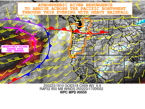
SUMMARY...An atmospheric river resurgence this afternoon and
evening will bring a new round of heavy rainfall to the Pacific
Northwest and especially for the coastal ranges and windward
slopes of the Cascades.

DISCUSSION...The latest GOES-W WV suite shows a negatively tilted
upper-level trough in between 40-50N and approaching 130W with an
occluded low center near 48N 142W. This energy will gradually
advance off to the northeast toward the Pacific Northwest and
British Columbia over the next 6 to 12 hours which will bring a
resurgence of stronger atmospheric river conditions back across
the region this afternoon through this evening.

A warm front that is currently oriented west to east across the
Columbia River basin will lift back northward with time as a
strong low to mid-level jet surges northeastward ahead of the
approaching offshore surface low and upper-level trough axis. This
will bring a resurgence of strong warm air advection and moisture
transport into the coastal ranges from far northwest CA up across
western OR and western WA through this evening.

IVT magnitudes are already increasing again across coastal
northwest CA and much of western OR and will be well into the 600
to 800+ kg/m/s range this afternoon through early this evening as
the offshore cold front approaches the region. These IVT values
will increase up across western WA as well, with magnitudes here
generally rising back as high as 400 to 600 kg/m/s.

PW anomalies of 2 to 3+ standard deviations above normal are
forecast through this evening ahead of the cold front and this
coupled with 850/700 mb moisture flux anomalies of 3 to 5+
standard deviations above normal should favor rainfall rates
reaching as high as 0.50" to 0.75"/hour. The heaviest rates should
tend to be focused across the OR coastal ranges and there is some
low-end potential for rates to even approach 1.0"/hour with
arrival of the strongest IVT parameters and forcing later this
afternoon. Enhanced IVT spillover into the windward slopes of the
Cascades should support at least spotty areas of a 0.50" to
0.75"/hour rates here, but the rates overall should tend to be
somewhat more modest farther north into western WA with lower IVT
values and lower PWs by comparison to western OR.

A cold front will advance inland by late this evening and this
will then allow for another break in the overall atmospheric
regime with rates once again then coming back down. However, at
least over the next 6 to 12 hours, expect additional rainfall
amounts of as much as 2 to 4 inches for western OR and 1 to 3
inches for western WA. These rains may bring additional concerns
regionally for runoff problems including small stream and urban
flooding.

Orrison

ATTN...WFO...EKA...MFR...OTX...PDT...PQR...SEW...

ATTN...RFC...CNRFC...NWRFC...NWC...

LAT...LON   49162120 48902067 48362056 47722062 47212097
            46512092 46222066 45892047 45722076 45502126
            45052150 44542152 43992163 43622194 42852201
            42442228 42462303 42222342 41652354 41792441
            43062470 44172437 46192417 47572457 48052414
            48012332 47762313 47512270 47632198 48432212
            49032186
Download in GIS format: Shapefile
| KML
Last Updated: 125 PM EST Sun Feb 23 2025
|


