| WPC Met Watch |
|
|
Mesoscale Precipitation Discussion: #0053 (2023) |
|
(Issued at 713 PM EST Sun Jan 29 2023
) |
|
| MPD Selection |
|
|
|
|
|

Mesoscale Precipitation Discussion 0053
NWS Weather Prediction Center College Park MD
713 PM EST Sun Jan 29 2023

Areas affected...Portions of southern Alabama and southwest
Georgia

Concerning...Heavy rainfall...Flash flooding possible

Valid 300013Z - 300513Z

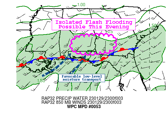
Summary...Isolated flash flooding will be possible through this
evening with rain rates approaching 1-2"/hr at times. Isolated
totals exceeding 3" are expected.

Discussion...Southwesterly flow aloft and an embedded shortwave
trough over Louisiana is providing the favorable large scale
forcing for ascent over the MPD region. The mean southwesterly
flow has allowed a surge of enhanced moisture to lift
northeastward across the region characterized by precipitable
water values in excess of 1.5" with isolated readings near 1.75"
per the latest blended TPW product. These values are between 2-2.5
standard deviations above normal for this time of year. Regional
radar continues to show overrunning precipitation with a
stationary boundary draped along the Gulf Coast.

The last several runs of the HRRR have been fairly consistent
showing a stripe of higher rain totals through 06Z across parts of
southern Alabama and southwest Georgia. The 18Z HREF showed a
moderate signal for 6-hr QPF exceeding 3" with hourly totals
between 1-2" possible for a few hours this evening. The much above
normal moisture and favorable setup for repeating rounds (storm
motions parallel to the mean flow) support this scenario, but the
main limiting factors are the relatively dry/normal antecedent
conditions (NASA SPoRT soil moisture 0-40 cm layer between 30-70
percent) and high flash flood guidance (1-hr 2.5"). Additionally,
forecast guidance continues to show that any available instability
will be further south toward the Gulf Coast.

However, the prolonged period of moderate to occasional heavier
downpours for several hours this evening could produce some
isolated instances of flash flooding.

Taylor

ATTN...WFO...BMX...FFC...MOB...TAE...

ATTN...RFC...SERFC...NWC...

LAT...LON   32438562 32418389 32108327 31228350 30938488
            30918627 31108694 31248723 32168700
Last Updated: 713 PM EST Sun Jan 29 2023
|


