| WPC Met Watch |
|
|
Mesoscale Precipitation Discussion: #0074 (2023) |
|
(Issued at 856 AM EST Fri Feb 24 2023
) |
|
| MPD Selection |
|
|
|
|
|

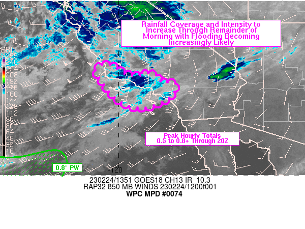
Mesoscale Precipitation Discussion 0074
NWS Weather Prediction Center College Park MD
856 AM EST Fri Feb 24 2023

Areas affected...southern CA

Concerning...Heavy rainfall...Flash flooding likely

Valid 241355Z - 241955Z

SUMMARY...Heavy rain coverage and intensity will expand across
southern CA through the rest of the morning. Peak rainfall rates
of 0.5 in/hr will increase above 0.8 in/hr through 20Z on a
localized basis. Additional rainfall of 2-4 inches over the next 6
hours is expected to increase the threat for flooding in the metro
locations and areas of terrain below snow levels.

DISCUSSION...GOES West water vapor imagery at 13Z showed a strong
closed low dropping southward off of the northern coast of CA with
the 12Z RAOB network sampling a 110 to 120 kt upper level jet from
VBG to VEF located southeast of the upper low center. Blended TPW
imagery depicted a broad shield of subtropical moisture advancing
toward the CA coast ahead of an occluded/cold front with values
over 0.8 inches along 30N and as far east as 123W. Areas of heavy
rain are ongoing from San Luis Obispo into Santa Barbara counties
with observed rainfall totals over 0.5 in/hr.

The closed low is forecast to continue advancing southward over
the next six hours which should support the continued transport of
moisture into the southern CA coast with precipitable water values
rising to over 0.8 inches by ~20Z. 850 mb winds of 30 to 50 kt
oriented SSW or perpendicular to the Transverse Ranges will
promote an ideal upslope component and orographic enhancement to
rainfall intensity. As the upper low advances south, mid-upper
level diffluence will increase along with some enhancement within
the right entrance region of the aforementioned upper level jet
max, supporting an expansion/increase of heavy rain from the coast
into the mountains. Snow levels are unusually low for this time of
year but will rise somewhat from current levels into the 5000-6000
ft range by early afternoon per recent NAM forecasts. Flooding
impacts are likely to increase over the next 3-6 hours, especially
with any exposed burn scar locations below snow levels and in
other areas of poor drainage. Peak additional rainfall totals
through 20Z are expected to range from 2-4 inches.

Otto

ATTN...WFO...LOX...SGX...

ATTN...RFC...CNRFC...NWC...

LAT...LON   35142057 34962018 34721981 34641960 34571940
            34581904 34591879 34781895 34671852 34601827
            34521826 34431829 34341812 34271807 34251794
            34291779 34221758 34251741 34141738 33671755
            33291823 33111888 33191950 33542010 34092060
            34852105
Last Updated: 856 AM EST Fri Feb 24 2023
|


