| WPC Met Watch |
|
|
Mesoscale Precipitation Discussion: #0093 (2023) |
|
(Issued at 140 AM EST Fri Mar 10 2023
) |
|
| MPD Selection |
|
|
|
|
|

Mesoscale Precipitation Discussion 0093
NWS Weather Prediction Center College Park MD
140 AM EST Fri Mar 10 2023

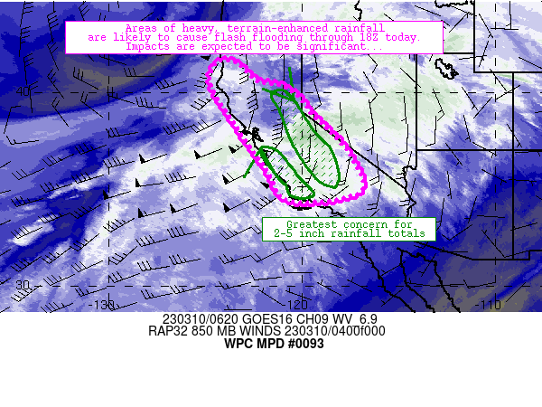
Areas affected...much of California

Concerning...Heavy rainfall...Flash flooding likely

Valid 100600Z - 101800Z

Summary...A landfalling atmospheric river is expected to continue
spreading heavy rainfall across most of California through 18Z
Friday.  Widespread areas of 1 inch rainfall totals are expected,
though terrain-favored upslope areas are expected to experience
2-5 inches of rainfall that could result in widespread, rapid
onset flooding especially where rainfall induces melting of
snowpack.

Discussion...An ongoing, landfalling atmospheric river continues
to produce widespread rainfall across many areas of the state
currently.  Environmental conditions supporting this landfalling
atmospheric river include 1) a gradually moistening airmass, with
1.3.1.5 inch PW values now approaching central coastal areas of
California and 2) gradually increasing low- to mid-level
west-southwesterly flow against the terrain - now exceeding 50
knots at 850mb in several places.  The combination of moisture and
upslope was resulting in mainly light rainfall over the discussion
area so far, with hourly rain rates of 0.1-0.25 inch/hr in most
areas.  Higher rainfall rates were estimated where terrain
influences were more pronounced (exceeding 0.25 inch/hr along
upslope areas of the Sierra and along localized areas of central
California coastal ranges per MRMS and observations).

The ongoing regime should continue through 18Z and beyond.  Models
indicate that an uptick in precipitation rates and totals are
likely through that time frame - especially in aforementioned
areas of enhanced upslope as wind fields remain strong (or even
increase slightly) and moisture continues to increase.  Heaviest
rainfall totals (ranging from 2-5 inches) are likely along upslope
regions of the southern Sierra and along central California
coastal ranges generally extending from Santa Barbara to
Monterrey.  These areas will also be aligned well with maximum
Integrate Water Vapor transport (exceeding 800 kg/m*s) through the
18Z.

Of particular concern is the existence of this heavy rainfall on
snowpack along upslope regions of the Sierra.  As snow levels rise
into the 8000-10000 foot range, rainfall on snowpack should result
in areas of increased runoff and rapid onset of flooding.
Additionally, areas of modest instability along coastal areas
could combine with terrain influences to boost rainfall rates into
the 0.5-1.25 inch/hr range at times.  Each of these scenarios
could contribute to significant, widespread flooding at times
today.

Cook

ATTN...WFO...EKA...HNX...LOX...MFR...MTR...REV...SGX...STO...
VEF...

ATTN...RFC...CNRFC...NWC...

LAT...LON   41572431 41512339 40572229 40302100 39612002
            38771941 37801838 36801753 35451687 34791706
            34501803 34331977 34582102 36012182 37402282
            38502356 39972450 40742474
Last Updated: 140 AM EST Fri Mar 10 2023
|


