| WPC Met Watch |
|
|
Mesoscale Precipitation Discussion: #0102 (2019) |
|
(Issued at 403 AM EDT Mon Mar 25 2019
) |
|
| MPD Selection |
|
|
|
|
|

Mesoscale Precipitation Discussion 0102
NWS Weather Prediction Center College Park MD
403 AM EDT Mon Mar 25 2019

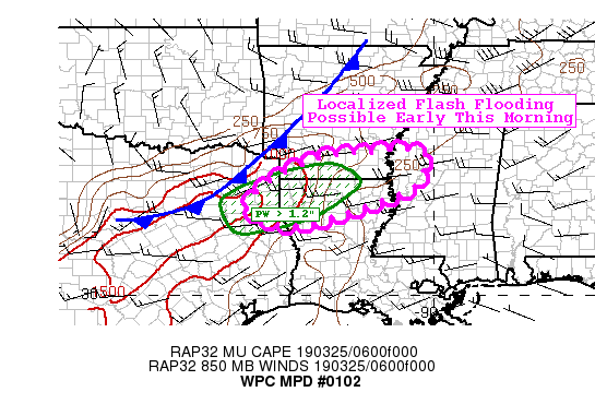
Areas affected...Southern AR...West-Central MS...Northern LA

Concerning...Heavy rainfall...Flash flooding possible

Valid 250802Z - 251102Z

Summary...A line of thunderstorms will slowly drift
south/southeast early this morning and be capable of producing
hourly totals up to 2" with localized 2-3" totals possible through
6 am CT.

Discussion...Convection that has formed along and ahead of cold
front continues to move slowly to the south/southeast early this
morning. This convection has been forming in a slightly more
favorable environment for heavy rain compared to earlier in the
night, evident by increasing PWs of 1.2-1.3" now across portions
of northeast TX, northern LA, and southern MS. MUCAPE values of
around 500 J/kg continue across the area as well. With the line of
convection now more oriented east/west with the mean flow, the
potential for training convection has increased. Recent radar
estimates indicate that hourly rates have picked up to over 1.5"
with some local observations showing 2"+ in the last few hours.

With this in mind and the potential for the line of convection to
maintain itself in the next 2-4 hours, there is a localized flash
flood threat across southern AR, northern LA and portions of
northeast TX and west-central MS early this morning. The main
limiting factor is the higher FFG values, but the repeating rounds
of intense rates with the potential for slightly longer duration
could lead to some flash flooding concerns.

Taylor

ATTN...WFO...JAN...LZK...SHV...

ATTN...RFC...LMRFC...WGRFC...

LAT...LON   33819084 33659020 33299025 32829053 32559114
            31839354 32219488 32969428 33589294 33729176
Last Updated: 403 AM EDT Mon Mar 25 2019
|


