| WPC Met Watch |
|
|
Mesoscale Precipitation Discussion: #0112 (2023) |
|
(Issued at 316 PM EDT Thu Mar 16 2023
) |
|
| MPD Selection |
|
|
|
|
|

Mesoscale Precipitation Discussion 0112
NWS Weather Prediction Center College Park MD
316 PM EDT Thu Mar 16 2023

Areas affected...Southern & Southeast OK...Northeast TX...Western
AR...Ext Northwest LA...

Concerning...Heavy rainfall...Flash flooding possible

Valid 161915Z - 170100Z

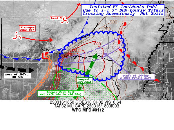
SUMMARY...Quick moving but increasingly efficient rainfall
production with sub-hourly totals of 1-1.5" ahead of the cold
front.  Isolated incidents of flash flooding are possible as these
cells intersect wetter soil conditions near the Red River as well
as areas affected by warm advection thunderstorms into the
OK/TX/AR region by late evening.

DISCUSSION...GOES-E IR/WV suite depicts two convective regimes
across the Southern Plains this afternoon as anomalous deep layer
broad trough emerges across the High Plains attm.  A lead smaller
scale  shortwave is lifting quickly out of north-central OK, while
the main core of vorticity energy is pressing east across the TX
Panhandle.  This is providing solid height-falls while maintaining
a strong LLJ across E TX pumping near record moisture values for
the date across a narrow warm sector.  CIRA LPW sfc-850mb layer
shows this well with .75"+ values into central TX generally
aligned with mid-60s Tds, though .5-.6" values extend into central
and eastern OK along the front.  While there a weak dry slot
across northwest TX, the LPW values depict the solid connection
back to the subtropical East Pacific, bringing total PWat values
of 1.25" across much of the warm sector, with a narrow axis of
1.5" building from Milam to Hunt to Lamar county, which is
expected to expand with time as layers align better this evening.
 This moisture and weak confluence on the eastern edge of th 50kt
LLJ has sparked slow moving warm advection thunderstorms.
Back-building and highly isolated training may allow for some
localized 1-2" totals, but not likely rising to flash flooding
conditions just yet.

Upstream...initially elevated convection across central OK has
enhanced cold front as it is starting to shift eastward with the
better height-falls aloft, the increased forward motion should
intersect LLJ a bit better though still at an oblique angle for
the next few hours.  Stronger instability and that weak dry slot
denoted in the 850-700mb layer in the LPW, have allowed for
increased instability for stronger updrafts...please see SPC MCD
291 for further details wrt severe weather.  Cells along the tail
of the cold front near a triple-point with the dry line in NW TX,
may allow for more discrete stronger supercells and as such, will
enhance isallobaric increased convergent sfc to boundary layer
flow and strengthen moisture flux convergence into broadening
updraft cores.  This will allow for higher rainfall efficiency
with time with HRRR 15 minute rain totals of 1-1.25" even with
faster eastward progression.  Duration may only be up to an hour,
but 1.25-1.75" totals in sub-hourly ranges may allow for localized
flash flooding conditions...especially after 22z as the cells move
into the deeper low level moisture axis (east of I-35).
Additionally, soil conditions are a bit more susceptible to higher
runoff given 200-300% of normal precip across the Red River Valley
from Young to Cooke to Choctaw, OK counties...where NASA SPoRT LIS
0-40cm soil ratios remain above normal at 65-70%.

After 00z, depending on the cells forward speed, these intense
short-term rates may intersect those areas affected by the
aforementioned 1-2" spots from the warm advection development of
Northeast TX into Western AR, sparking a slightly higher
probability of flash flooding situations.

Gallina

ATTN...WFO...FWD...LZK...OUN...SHV...TSA...

ATTN...RFC...ABRFC...LMRFC...WGRFC...NWC...

LAT...LON   35709463 35639377 35099329 33879330 32689372
            32059503 32609645 32809730 32999805 33549829
            34659775 35309658 35649557
Last Updated: 316 PM EDT Thu Mar 16 2023
|


