| WPC Met Watch |
|
|
Mesoscale Precipitation Discussion: #0129 (2023) |
|
(Issued at 448 AM EDT Sun Mar 26 2023
) |
|
| MPD Selection |
|
|
|
|
|

Mesoscale Precipitation Discussion 0129
NWS Weather Prediction Center College Park MD
448 AM EDT Sun Mar 26 2023

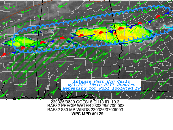
Areas affected...East-central MS...Central AL...West-central &
Central GA

Concerning...Heavy rainfall...Flash flooding possible

Valid 260850Z - 261430Z

SUMMARY...Fast moving but quick hitting thunderstorms capable of
1.25"/15 min within a favorable environment for repeating cells
may pose isolated spots of 2-3" through early morning hours and
possible localized flash flooding concerns.

DISCUSSION...08z surface analysis depicts a west-southwest to
east-northeast frontal zone from S MS, central AL toward ENE GA.
Shallow but very moist/unstable air mass is returning off the Gulf
with mid-60s to low 70s surface Tds supporting sfc-850mb Pwats
over .8 to near 1".  Southerly confluent boundary layer flow has
lifted across the boundary with sufficient moisture flux
convergence to break out individual cells along the front from far
E MS into central AL to the GA border.  High lapse rates above the
moist layer/dry air are supporting large hail, but the flux and
ample moisture is also supporting efficient rainfall production
with a few sites reporting .3-.4" in 5 to 10 minutes across
east-central AL so far.

Currently, fast shallow layer steering is supporting very fast
movement that has limited overall totals at or below 1" and
coverage has remained limited to due weaker upglide/convergence.
However, coverage is expected to increase with broader/slightly
stronger convergence along the length of the frontal zone.  Given
deep layer flow will remain generally parallel to the boundary,
there is growing potential for repeating cells.  While the rates
are fairly intense (up to 1.25"/15 minutes per HRRR), it will take
multiple rounds to lead to flash flooding across this higher
capacity environment/soils (with 1hr FFG values of 2-2.5" and 3hr
2.5-3"); though the intensity with each round will be high enough
to quickly overwhelm areas that had elevated run-off from the
first round. As such, isolated incidents of flash flooding are
considered possible, particularly toward 12-15z and further east
where repeat potential will be higher.

Gallina

ATTN...WFO...BMX...FFC...JAN...

ATTN...RFC...LMRFC...SERFC...NWC...

LAT...LON   33988323 33208294 32638525 32518636 32438728
            32298904 32818929 33128874 33278779 33458664
            33748507
Last Updated: 448 AM EDT Sun Mar 26 2023
|


