| WPC Met Watch |
|
|
Mesoscale Precipitation Discussion: #0133 (2020) |
|
(Issued at 307 PM EDT Thu Apr 09 2020
) |
|
| MPD Selection |
|
|
|
|
|

Mesoscale Precipitation Discussion 0133
NWS Weather Prediction Center College Park MD
307 PM EDT Thu Apr 09 2020

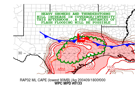
Areas affected...Portions of Central and Eastern TX

Concerning...Heavy rainfall...Flash flooding possible

Valid 091905Z - 100105Z

SUMMARY...Showers and thunderstorms will be increasing in coverage
and intensity this afternoon across portions of central and
eastern TX. Given very intense short-term rainfall rates, a few
incidences of flash flooding may result.

DISCUSSION...The latest WV/IR satellite imagery shows a broadly
diffluent flow pattern across the southern Plains with a
well-defined subtropical jet crossing from the eastern tropical
Pacific northeast across mainland Mexico and the Rio Grande
Valley. Weak shortwave energy embedded within the deep layer
southwest flow is seen beginning to interact with a frontal zone
draped over portions of central TX, along with an extremely
favorable thermodynamic environment that will be conducive for
widespread convection this afternoon and evening. In fact, radar
imagery is already showing a broken band of showers and
thunderstorms west of Waco and Austin, and to the south of
Brownwood with upscale growth and cloud-top cooling noted over the
last hour.

The activity is expected to grow further in coverage and
organization in the hours ahead as the convection interacts with
an environment characterized by MLCAPE values increasing to 3000
to 4000 j/kg, PWs approaching 1.5 inches, and 50 to 60 kts of
effective bulk shear. The low-level inflow ahead of this
afternoon's convection is not especially good, with values
generally under 20 kts, but there is decent frontal convergence
overall, and this coupled with the robust thermodynamic
environment and forcing aloft should still yield a well-organized
convective event with multiple evolving convective clusters and a
few cell-mergers.

The 12Z HREF mean favors as much as 2 to 3 inches of rain in as
little as 1 to 2 hours, and these intense rainfall rates will be
aided in part by the moist 500/300 mb layer eastern tropical
Pacific moisture transport regime that is in place, in addition to
very moist low-levels and the aforementioned instability.

Areas of central TX, especially closer into the Austin area have
been relatively wet over the last couple of weeks, and so this
coupled with the intense rain rates would favor some locally
enhanced runoff concerns. Thus, a few incidences of flash flooding
will be possible going through the afternoon and evening hours,
with an emphasis on the more sensitive urban centers and adjacent
suburbs. While the activity will be more focused on central TX
over the next couple of hours, areas farther east with time will
see the convective rainfall threat on the increase as well.

Orrison

ATTN...WFO...EWX...FWD...HGX...LCH...SHV...

ATTN...RFC...WGRFC...

LAT...LON   31739582 31649501 31349421 30929376 30299389
            30099440 29879531 29609618 29099701 29099830
            29379892 29869908 30439850 31319780 31709696
Last Updated: 307 PM EDT Thu Apr 09 2020
|


