| WPC Met Watch |
|
|
Mesoscale Precipitation Discussion: #0135 (2023) |
|
(Issued at 1007 PM EDT Sun Mar 26 2023
) |
|
| MPD Selection |
|
|
|
|
|

Mesoscale Precipitation Discussion 0135
NWS Weather Prediction Center College Park MD
1007 PM EDT Sun Mar 26 2023

Areas affected...Central Alabama...Central Georgia

Concerning...Heavy rainfall...Flash flooding likely

Valid 270200Z - 270700Z

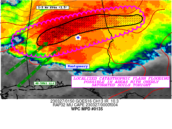
SUMMARY...A corridor of intense thunderstorms will continuously
track over areas of central AL and central GA tonight where soils
are sensitive from recent heavy rainfall. Hourly rainfall rates of
2-2.5"/hr are expected and likely results in localized
catastrophic flash flooding tonight.

DISCUSSION...Latest HRRR guidance has continued to hone in on the
ongoing areas of robust convection stemming from central AL to
central GA as the focus for training storms. SPC mesoanalysis
shows up to 2,000 J/kg of MUCAPE while PWs are increasing to
1.75". The mean 850-300mb mean flow and bulk effective shear
remains parallel to the frontal boundary while the LCL-LFC mean RH
values are now at or above 90% saturated. Latest HRRR shows a
southwesterly 50 knot LLJ will intersect the front while there is
also plenty of strong vertical ascent atop the atmosphere as the
region is beneath the right-entrance region of a 140 knot 250mb
jet streak. Lastly, there is no shortage of vertical wind shear as
SPC mesoanalysis shows 60-70 kts worth of effective bulk shear and
200-300 m2/s2 of effective SRH available to maintain organized
strong-to-severe storms into the overnight hours. Look for the
developing area of thunderstorms over northern LA and central MS
to act as a fire hose, delivering more rounds of strong
thunderstorms into central AL and central GA overnight.

The prolonged feed of rich low level moisture into and along the
frontal boundary, combined with ample instability and organized
convection tracking over sensitive soils is the blue print to a
potentially dangerous flash flood event. FFGs have steadily
dropped from not only this morning's heavy rainfall (which
produced 2-5" of rain), but also the initial thunderstorm activity
from this afternoon. 1-3hr FFGs are <1.5" in the black outlined
area, where thunderstorms will be capable of producing 2"/hr
rainfall rates and potentially approach 2.5"/hr in the most
intense convection. These locations, as well as poor drainage
areas and urbanized communities, are most vulnerable to flash
flooding. Given the longevity of this line of storms, expect some
roads to be flooded with flowing water over roads in some cases.
Flooding on roadways will also be very difficult to identify with
the sun now set. Watch for potential flooding in basements as
well. The potential for localized catastrophic flash flooding will
continue into the overnight hours.

Mullinax

ATTN...WFO...BMX...FFC...JAN...MOB...

ATTN...RFC...LMRFC...SERFC...NWC...

LAT...LON   33548446 33498390 32958375 32378507 31688740
            31848876 32488886 32978758 33138688 33388573
Last Updated: 1007 PM EDT Sun Mar 26 2023
|


