| WPC Met Watch |
|
|
Mesoscale Precipitation Discussion: #0149 (2019) |
|
(Issued at 1116 PM EDT Sun Apr 21 2019
) |
|
| MPD Selection |
|
|
|
|
|

Mesoscale Precipitation Discussion 0149
NWS Weather Prediction Center College Park MD
1116 PM EDT Sun Apr 21 2019

Areas affected...Eastern Nebraska

Concerning...Heavy rainfall...Flash flooding possible

Valid 220315Z - 220645Z

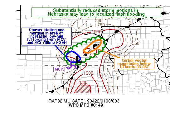
Summary...Slow-moving thunderstorms may have a brief time window
tonight to produce localized heavy rainfall and flash flooding.
Rain rates may reach 1-2 inches per hour with three-hour rainfall
up to around 3 inches.

Discussion...Recent radar loops from KUEX and KOAX reveal several
strong convective lines and clusters in eastern Nebraska. The
storm motions were substantially reduced in two key areas. First,
KUEX radar clearly showed a mesoscale convective vortex (MCV)
drifting northeast about 60mi SW of Hastings (KHSI); a convective
outflow boundary was racing out ahead of that to the north and
northeast, but curled back close to the MCV in south-central
Nebraska. This was leading to concentrated convection on the
northwest flank of the MCV. This area of low-mid level forcing was
also increasingly overlapping with 925-700mb frontogenesis
associated with the synoptic scale low from Holdrege (KDE) north
to Broken Bow (KBBW). This has the potential to lead to a couple
hours of persistent convective activity, anchored with relatively
stationary forcing mechanisms and weaker flow. Second, KOAX radar
shows a right-moving supercell just west of KOLU, with some
trailing upshear convection. These storms were in a region of
extremely low Corfidi vector magnitudes along the stationary
front, with values generally 10 knots or less (near 0 in some
locations). This was supporting slow storm motions overall, and
particularly with backbuilding storms as they drifted over the
primary precipitation swath from the supercell. Atmospheric
moisture content was not particularly supportive of heavy
rainfall, with PWs generally less than 1 inch (KOAX 00Z sounding;
CIRA blended TPW; GPS-PW observations). However, sufficient
instability exists for organized convection, and the slow storm
motions should compensate for a relatively inefficient environment
for rainfall. Rain rates of 1-2 inches per hour would be a
reasonable expectation. In a region with three-hour FFG generally
2.0 to 2.5 inches, hydrologic conditions would support at least
some chance of flash flooding. This would be most likely if the
heavy rain rates intersect a developed population center for a
couple hours.

Lamers

ATTN...WFO...FSD...GID...LBF...OAX...

ATTN...RFC...MBRFC...

LAT...LON   42459687 42099643 41679645 41129714 40169914
            40789991 41409934 42029797
Last Updated: 1116 PM EDT Sun Apr 21 2019
|


