| WPC Met Watch |
|
|
Mesoscale Precipitation Discussion: #0157 |
|
(Issued at 758 AM EDT Tue Apr 22 2025
) |
|
| MPD Selection |
|
|
|
|
|

Mesoscale Precipitation Discussion 0157
NWS Weather Prediction Center College Park MD
758 AM EDT Tue Apr 22 2025

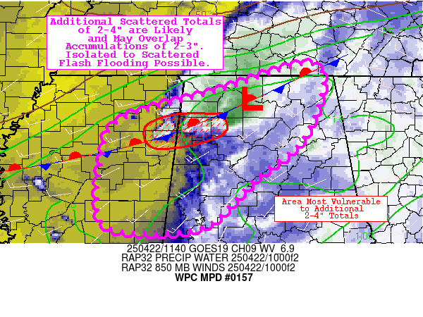
Areas affected...portions of north-central AL and northeast MS

Concerning...Heavy rainfall...Flash flooding possible

Valid 221200Z - 221800Z

Summary...Additional scattered totals of 2-4" are likely and may
overlap accumulations of 2-3" from early this morning/overnight.
Isolated to scattered instances of flash flooding are possible.

Discussion...Convection has been percolating over the past several
hours over northwestern AL into far northeast MS, in the vicinity
of a weak, stalling surface front and low pressure. While not
overly impressive synoptically, a weak shortwave aloft is noted
with an associated 50-60 kt (mini) jet streak, providing just
enough divergence aloft to support sustained convection (with 0-6
km shear of only about ~20 kts). Meanwhile, the low-levels are
becoming increasingly supportive of sustaining convection as well,
as weak 925-850 mb moisture transport has prevented convection
from becoming outflow dominate with 3-hr change in ML CAPE of
50-150 J/kg (resulting in current ML CAPE of 250-750 J/kg).
Precipitable water of 1.5" (above the 90th percentile, per BMX
sounding climatology) has supported occasional rainfall rates to
1.0-1.5"/hr (per MRMS estimates, as the peak rainfall rates have
occurred in observation sparse areas).

Going forward, there's a good chance that some of the recent
trends of backbuilding convection will continue, as upwind
propagation vectors in the vicinity of the convection are 5 kts or
less (taking into account the mean storm flow and opposite flow of
the 850 mb jet). In addition, storm motions are also relatively
slow (10-15 kts), so the combination of backbuilding and
appreciable individual cell residence time may occasionally
support hourly rates/totals on the order of 2-3"/hr. Overall the
00z/06z CAMs are struggling with the depiction of convection in
the region, though the 00z FV3 is an outlier in depicting 2-4"
totals through 15-18z (though this may be displaced too far
south). More recent HRRR runs (since 06z) are doing a better job
depicting convection in the correct location, though still
probably a bit too weak given the trends (only showing highly
isolated totals of 2"+). Thinking additional scattered totals of
2-4" are likely through 18z, and much of this could occur over
areas that have already seen 2-3" this morning. Given that the
realization of any flash flooding is dependent on localized
training of convection with overall weak forcing and relatively
high uncertainty, isolated to scattered flash flooding is
considered possible.

Churchill

ATTN...WFO...BMX...HUN...JAN...MEG...

ATTN...RFC...LMRFC...SERFC...NWC...

LAT...LON   35158589 34028607 33268695 32578762 32408843
            32518937 33068950 33568943 34238915 34708760
Download in GIS format: Shapefile
| KML
Last Updated: 758 AM EDT Tue Apr 22 2025
|


