| WPC Met Watch |
|
|
Mesoscale Precipitation Discussion: #0159 |
|
(Issued at 155 PM EDT Tue Apr 16 2024
) |
|
| MPD Selection |
|
|
|
|
|

Mesoscale Precipitation Discussion 0159
NWS Weather Prediction Center College Park MD
155 PM EDT Tue Apr 16 2024

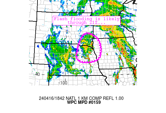
Areas affected...northeastern Nebraska, far southeastern South
Dakota, and far western Iowa

Concerning...Heavy rainfall...Flash flooding likely

Valid 161732Z - 162132Z

Summary...A nearly stationary complex of storms continues to
produce 1-2.5 inch/hr rain rates and has done so for several
hours. Flash flooding is likely through 21Z.

Discussion...An axis of convection has remained nearly stationary
across northeastern Nebraska over the past 3-4 hours while
producing periods of 1-2.5 inch/hr rain rates at times.  The
convection is generally oriented along a line from Yankton, SD to
Norfolk, NE to Columbus, NE, with backbuilding on its southern
flank continuing to support nearly stationary and erratic movement
with the complex.  Easterly low-level flow was maintaining a fetch
of near 60F dewpoints into the area of convection.  Meanwhile, an
outflow boundary has matured along the rainfall axis and southerly
flow aloft continues to help the complex maintain its very slow
motion along with backbuilding.  Cold temperatures aloft also
support moderate surface-based instability in the pre-convective
environment near the storms, further supporting robust updrafts.

The ongoing scenario will change little over the next couple
hours, with spots of 1-2.5 inch/hr rain rates continuing over the
area through 19Z.  Thereafter, convective trends are a bit
uncertain and will depend on evolution and propagation of the cold
pool.  Given the proximity of the mid/upper low and cold air
aloft, it appears that at least some threat of heavier downpours
will persist through most of the afternoon even though the cold
pool is likely to begin shifting slowly northeastward over the
course of the afternoon.  Another 1-3 inches of precipitation is
possible atop the nearly 2-5 inch totals that have already
developed (estimated per MRMS).  Flash flooding is likely in this
scenario.

Cook

ATTN...WFO...FSD...GID...LBF...OAX...

ATTN...RFC...MBRFC...NWC...

LAT...LON   43819772 43649624 42789562 41609592 41359773
            41909853
Download in GIS format: Shapefile
| KML
Last Updated: 155 PM EDT Tue Apr 16 2024
|


