| WPC Met Watch |
|
|
Mesoscale Precipitation Discussion: #0172 (2021) |
|
(Issued at 457 PM EDT Tue May 11 2021
) |
|
| MPD Selection |
|
|
|
|
|

Mesoscale Precipitation Discussion 172
NWS Weather Prediction Center College Park MD
457 PM EDT Tue May 11 2021

Areas affected...South-central Texas

Concerning...Heavy rainfall...Flash flooding possible

Valid 112056Z - 120300Z

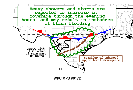
SUMMARY...Increasing coverage of showers and storms with high
rainfall rates is expected across portion of south-central Texas
through 10 pm local time.  Some instances of flash flooding will
be possible where convective training or cell mergers develop.

DISCUSSION...GOES-E Infrared and regional RADAR mosaic denote
continued convective development and cooling cloud tops over north
central Mexico and the southern Hill Country of southern Texas
this afternoon, mainly along and south of a quasi-stationary
front.  Lines of training convection have already developed, and
these should persist going into the evening hours.  Slow moving
cells just south of the Rio Grande will also produce heavy
rainfall as they move towards the east.

The latest suite of CAM guidance is suggesting the potential for
localized 2 to 4 inch rainfall totals through 10 pm local time,
with the highest confidence of this becoming realized between San
Antonio, Laredo, and Corpus Christi.  This is where the best
combination of 200-400mb divergence, boundary layer moisture
convergence, and instability (ML CAPE in excess of 3000 J/kg) will
likely exist.  In addition, the latest RAP model indicates PWs
increasing to over two inches after 5 pm, providing fuel for
future convection.  Portions of the outlook area have already
received 1-2+ inches of rainfall over the past 24 hours, and these
areas are slightly more vulnerable to any additional rainfall.
Flash flooding will be possible with rainfall rates potentially
exceeding two inches per hour with the strongest convection.

Hamrick

ATTN...WFO...CRP...EWX...FWD...HGX...

ATTN...RFC...WGRFC...NWC...

LAT...LON   30579746 30559714 30379665 30219623 29839614
            29379641 28759682 28349733 27979800 27739868
            27589920 27549960 27739998 28090028 28520056
            29380102 29830054 29909972 29949944 30039895
            30199843 30459787
Last Updated: 457 PM EDT Tue May 11 2021
|


