| WPC Met Watch |
|
|
Mesoscale Precipitation Discussion: #0181 |
|
(Issued at 1238 AM EDT Sat Apr 27 2024
) |
|
| MPD Selection |
|
|
|
|
|

Mesoscale Precipitation Discussion 0181
NWS Weather Prediction Center College Park MD
1238 AM EDT Sat Apr 27 2024

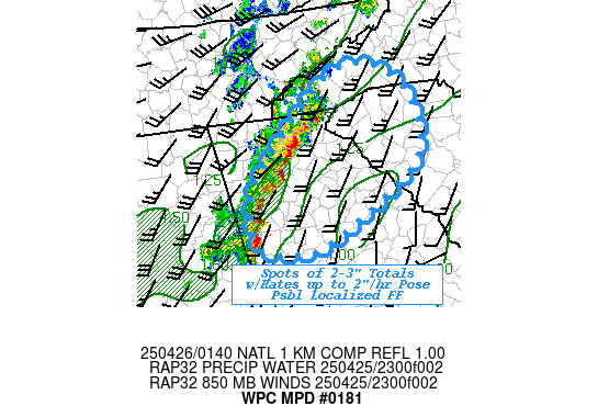
Areas affected...Far Northern LA...Southern AR

Concerning...Heavy rainfall...Flash flooding possible

Valid 270437Z - 270837Z

SUMMARY...A localized threat for flash flooding will exist from
small-scale areas of training showers and thunderstorms.

DISCUSSION...The latest radar imagery shows a band of heavy
showers and thunderstorms situated over areas of far northern LA
and into southern AR. The activity has been focusing along the
leading edge of an outflow boundary which has been tending to slow
down and become oriented in a southwest to northeast fashion
across the region.

There is also a shortwave trough crossing into the Lower MS
Valley, and this energy is interacting with this surface boundary
along with the nose of a moderately unstable airmass pooled along
it. MLCAPE values are locally as high as 1000 to 1500 J/kg, and
this coupled with PWs of 1.5 to 1.6 inches is driving rainfall
rates of locally 2 to 3 inches/hour.

This convective activity may linger for a few more hours and tend
to train a bit more over the same area. Given the high rainfall
rates, and localized persistence of it, some small-scale rainfall
totals of 3 to 5 inches will be possible. Therefore, some isolated
flash flooding will be possible.

Orrison

ATTN...WFO...JAN...LZK...MEG...SHV...

ATTN...RFC...LMRFC...NWC...

LAT...LON   34219103 33899067 33069155 32699237 32709294
            33039301 33779212
Download in GIS format: Shapefile
| KML
Last Updated: 1238 AM EDT Sat Apr 27 2024
|


