| WPC Met Watch |
|
|
Mesoscale Precipitation Discussion: #0204 |
|
(Issued at 920 PM EDT Wed Apr 30 2025
) |
|
| MPD Selection |
|
|
|
|
|

Mesoscale Precipitation Discussion 0204
NWS Weather Prediction Center College Park MD
920 PM EDT Wed Apr 30 2025

Areas affected...central/east Texas and far western Louisiana

Concerning...Heavy rainfall...Flash flooding possible

Valid 010120Z - 010720Z

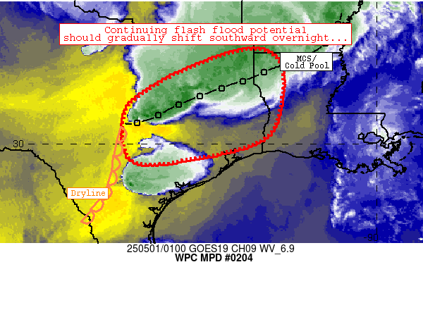
Summary...Areas of flash flooding remain possible along and ahead
of an elongated, southward-moving MCS.  1-2 inch/hr rain rates
remain likely, which could cause flooding issues especially in
sensitive/urban areas.

Discussion...An elongated MCS continues to migrate slowly
southward and is currently located along an axis from near Temple
to Shreveport.  Individual cells/clusters within the broader MCS
are initiating closer to stronger mid-level instability across
central Texas and migrating eastward, resulting in extensive
training and multiple areas of 1-2 inch/hr rain rates at times.
Heavier rain rates have persisted for multiple hours, resulting in
spots of 2-5 inch rainfall totals (per MRMS radar estimates) These
rain rates have resulted in scattered impacts (especially between
Waco and Tyler).  These rates are exceeding FFG thresholds on a
spotty basis, as 3-5 inch/hr FFG thresholds are prevalent across
much of Texas east of I-35 and south of I-20.

The ongoing convective scenario supporting flash flooding should
continue to translate southward over the next 4-6 hours.  However,
flash flood potential should become progressively more isolated as
a result of 1) continued high FFG thresholds south of the ongoing
MCS, and 2) veering/weakening 850mb flow, which should ultimately
result in less convergence/convective coverage within the MCS.
Flash flooding remains possible especially where heavier rain
rates (exceeding 1 inch/hr) 1) reside over local areas of multiple
hours and/or 2) fall over urban/sensitive ground conditions.

Cook

ATTN...WFO...EWX...FWD...HGX...LCH...SHV...

ATTN...RFC...LMRFC...WGRFC...NWC...

LAT...LON   33139422 32769326 31569314 30239367 29619561
            29439804 31009834 31819751 32579605
Download in GIS format: Shapefile
| KML
Last Updated: 920 PM EDT Wed Apr 30 2025
|


