| WPC Met Watch |
|
|
Mesoscale Precipitation Discussion: #0206 |
|
(Issued at 826 PM EDT Thu May 01 2025
) |
|
| MPD Selection |
|
|
|
|
|

Mesoscale Precipitation Discussion 0206
NWS Weather Prediction Center College Park MD
826 PM EDT Thu May 01 2025

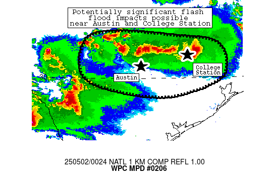
Areas affected...portions of central Texas

Concerning...Heavy rainfall...Flash flooding likely

Valid 020025Z - 020225Z

Summary...Heavy rainfall continues to pose a locally signficant
flash flood risk - especially northwest through northeast of
Austin, TX metro.

Discussion...A combination of supercellular and outflow-dominant
clusters have produced rain rates of 2-3 inches per hour and
nearly 7 inches in 3 hours along an axis from near Burnet/Buchanan
Dam eastward to near Hearne, TX.  Recent radar imagery indicates a
gradual increase in both 1) the presence of outflows spreading
away from heavier cores near this activity and 2) overall
convective coverage.  These trends were occurring amid a modest
increase in low-level flow, which has helped to maintain an influx
of moist (1.5 inch PW) and strongly unstable (4000 J/kg MLCAPE)
air into the storms.

Though the exact evolution is still a bit uncertain, some concern
exists that upscale growth could both 1) allow for a longer
duration of heavier precipitation into the evening than depicted
by most CAMs that 2) ultimately spreads impacts closer to
populated areas such as Austin and College Station.  Given the
magnitude of rain rates (2+ inches/hr), these impacts could become
significant.

Cook

ATTN...WFO...EWX...FWD...HGX...SJT...

ATTN...RFC...WGRFC...NWC...

LAT...LON   31349847 31219647 31039519 30479483 29889519
            29479706 29969943 31079950
Download in GIS format: Shapefile
| KML
Last Updated: 826 PM EDT Thu May 01 2025
|


