| WPC Met Watch |
|
|
Mesoscale Precipitation Discussion: #0208 |
|
(Issued at 414 AM EDT Thu May 02 2024
) |
|
| MPD Selection |
|
|
|
|
|

Mesoscale Precipitation Discussion 0208
NWS Weather Prediction Center College Park MD
414 AM EDT Thu May 02 2024

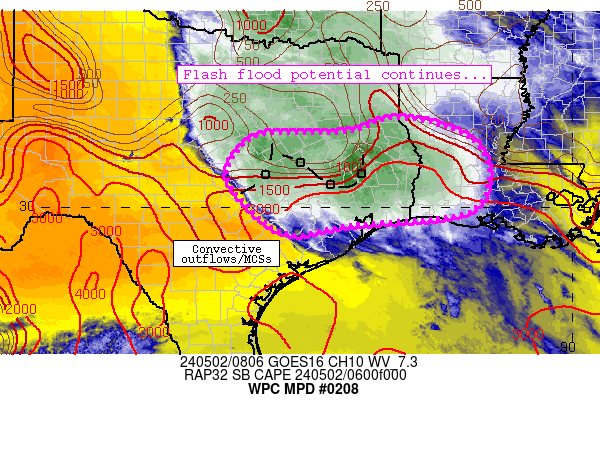
Areas affected...central into southeast Texas, portions of
southwestern/central Louisiana

Concerning...Heavy rainfall...Flash flooding likely

Valid 020813Z - 021413Z

Summary...Complicated convective scenario will continue to pose a
potentially significant flash flood risk through 14Z this morning.

Discussion...The ongoing convective scenario is described by a
couple of prominent linear segments - one about 50 miles NNE of
Houston Metro and a second between Austin and Temple.  Weaker
convection persists between these two dominant linear segments,
although the Austin/Temple complex has shown a weakening trend
over the past hour - likely due to low-level trajectories from
rain-cooled air over east-central Texas.  The pre-convective
environment (away from any outflow or ongoing convection) remains
very moist (2 inch PW values) and unstable (~2000 J/kg MLCAPE),
with strong southerly 850mb flow perpendicular to subtle outflows
in vicinity of the convection to support occasional
backbuilding/training.  The complex has exhibited periods of both
slow/nearly stationary and fast forward movement at times,
enabling periods of 2-4 inch/hr rain rates and 5-9 inch storm
totals across portions of the discussion area.  Significant
impacts have also been noted at times.

The ongoing, complicated forecast scenario poses substantial
uncertainty over the next 6 hours.  Current thinking is that the
ongoing linear complex northeast of Houston will maintain its
intensity while moving east-northeastward toward southwestern
Louisiana parishes through the morning.  Continued backbuilding
will occur between this MCS and an upstream MCV (centered near
ACT/Waco) and continue to spread heavy rain and at least 1 inch/hr
rain rates across water-logged areas that experienced 2-7 inches
of rainfall earlier.  These cells appear to be slightly elevated,
which may be hindering intensity/rain rates in the short term.

One key uncertainty regarding the ongoing scenario is whether
convection can deepen near/south of US 290 between Austin and
Houston, where better surface-based instability resides.
Surface-based development in this region could result in upscale
growth of another linear complex with training characteristics
that promote both 1) 2-4 inch/hr rain rates at times while 2)
potentially affecting more populated areas closer to Houston
Metro.  Although uncertain, a significant flash flood episode
would be likely - especially if the the scenario depicted by the
06Z HRRR run were to materialize.

Cook

ATTN...WFO...EWX...FWD...HGX...LCH...SHV...

ATTN...RFC...LMRFC...WGRFC...NWC...

LAT...LON   32059373 31789276 31299209 30429200 29829265
            29609512 29389661 30059761 30809806 31599753
            31729677 31719584 31819500 32039443
Download in GIS format: Shapefile
| KML
Last Updated: 414 AM EDT Thu May 02 2024
|


