| WPC Met Watch |
|
|
Mesoscale Precipitation Discussion: #0209 |
|
(Issued at 423 AM EDT Fri May 02 2025
) |
|
| MPD Selection |
|
|
|
|
|

Mesoscale Precipitation Discussion 0209
NWS Weather Prediction Center College Park MD
423 AM EDT Fri May 02 2025

Areas affected...South-Central & Eastern OK...Far Northern
TX...Northern AR...

Concerning...Heavy rainfall...Flash flooding likely

Valid 020830Z - 021430Z

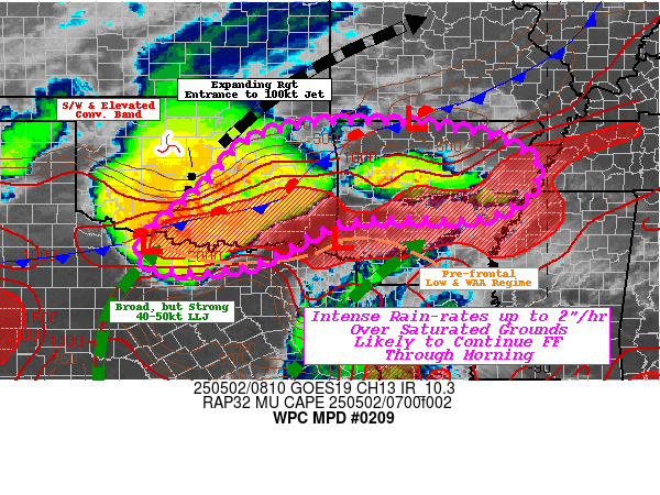
SUMMARY...Fast moving, but intense cores capable of 1"/15-30
minutes and localized totals of 2-3.5" crossing saturated ground
conditions likely to continue scattered flash flooding incidents
through early morning.

DISCUSSION...GOES-E 10.3um loop shows expanding cooling complex
along the Red River in SW OK/NW TX.  RADAR mosaic shows a more
detail to the driving forces, with fast moving S/W almost MCV like
mid-level circulation across northwest OK with a bowed arch of
elevated thunderstorms angling southward with some 700mb boundary
starting to activate west to east downstream of the SW into the
sharpening right entrance of the 300mb jet.  WV suite notes that
the larger scale main vorticity center is sharpening the overall
height packing and the jet is starting to accelerate to 100kts.
This is providing solid divergence aloft along and downstream to
maintain the wave, while simultaneously continuing to keep the
broad (nearly Texas wide) 40-50kt 850mb low level jet streaming
northward.  Upstream edge is starting to angle/veer more
southwestward, potentially expanding back-building of the flanking
line of the developing convective complex near a weak closing
1007/8mb surface low near KCWC.

A main surface front continues to bisect the state into NW AR,
though a subtle either southern stream or wake pressure trof
exists south of it and south of the Red River connecting to a weak
low near DEQ and southeast angling surface trof across S AR.  Both
are enhancing surface to boundary layer moisture convergence and
isentropic ascent, eventually tapping a solid remaining well of
2000-3000 MUCAPE.   While moisture flux into the boundaries
continues to help pool total moisture to 1.25-1.5", the orthogonal
ascent and strong convergence is increasing rates to 1.5-2"/hr.
As such, strong thunderstorms will continue to be maintained
across much of southern OK; however,the veered eastern edge of the
LLJ is starting to ascend over that southern boundary, utilizing
the instability axis over central AR and breaking out
thunderstorms across generally in the vicinity of I-40.  Deep
layer steering through much of the WAA regime may reduce some
cross track/repeating in the near term, but as the shortwave
approaches may flatten for increasing repeat/training environment
as is ongoing across southern OK.

So with increased duration, spots of 2-3.5" totals are possible
along the boundaries.  This alone is likely to exceed FFG in the
region, but those values may have rebounded much too quickly given
other soil saturation signals from NASA SPoRT.  0-40cm ratios
across most of the area of the MPD are over 70-75%, though the
lowest areas in central to northeast AR are still well over 60%
and are above normal with the vast majority of OK, NW and W AR in
the 90th percentile.  As such, limited infiltration suggests that
much rainfall over saturated grounds and elevated stream flows
will likely continue flash flooding concerns throughout the late
overnight through early morning day break.

Gallina

ATTN...WFO...FWD...LZK...MEG...OUN...SHV...TSA...

ATTN...RFC...ABRFC...LMRFC...WGRFC...NWC...

LAT...LON   36439462 36389273 36149122 35759043 35489020
            35009038 34629092 34449164 34459321 34359444
            33469635 33389821 33929857 35189715 36059633
Download in GIS format: Shapefile
| KML
Last Updated: 423 AM EDT Fri May 02 2025
|


