| WPC Met Watch |
|
|
Mesoscale Precipitation Discussion: #0212 |
|
(Issued at 800 PM EDT Fri May 02 2025
) |
|
| MPD Selection |
|
|
|
|
|

Mesoscale Precipitation Discussion 0212
NWS Weather Prediction Center College Park MD
800 PM EDT Fri May 02 2025

Areas affected...Portions of South-Central and Southeast
TX...Southwest LA

Concerning...Heavy rainfall...Flash flooding possible

Valid 030000Z - 030600Z

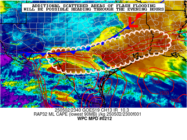
SUMMARY...Locally heavy showers and thunderstorms will continue
through the evening hours. Additional scattered areas of flash
flooding will continue to be possible where slow cell-motions and
cell-mergers yield enhanced rainfall totals.

DISCUSSION...The early-evening GOES-IR satellite imagery along
with dual-pol radar shows broken areas of heavy showers and
thunderstorms focusing along and just ahead of a slow-moving cold
front settling down across south-central to southeast TX.

Over the last couple of hours, there has been a trend toward
locally more organized convection and colder cloud tops in a
broken fashion from near Del Rio eastward to the southern suburbs
of the Austin metropolitan area. Meanwhile, farther east into the
southeast TX coastal plain and adjacent areas of southwest LA,
clusters of convection continue to persist here while slowly
advancing eastward.

A substantial pool of instability is pooled across much of
southern TX in close proximity to the front with MLCAPE values of
2500 to 3500 J/kg in place along with about 40 to 50 kts of
effective bulk shear. This coupled with at least modest low-level
south to southeast flow into the front should sustain the
convective threat going through the evening hours.

Slow cell-motions and cell-merger activity will continue to be a
short-term concern which given the moist/unstable environment
should continue to support rainfall rates of up to 2 inches/hour.

Additional rainfall amounts through the evening hours may reach as
high as 2 to 4 inches with isolated heavier totals. This will
continue to promote additional concerns for scattered areas of
flash flooding.

Orrison

ATTN...WFO...CRP...EWX...FWD...HGX...LCH...SHV...

ATTN...RFC...LMRFC...WGRFC...NWC...

LAT...LON   31369425 31349316 30799235 29999275 29629423
            28949612 28459847 28540037 29440139 29900117
            30099909 30569712 31099543
Download in GIS format: Shapefile
| KML
Last Updated: 800 PM EDT Fri May 02 2025
|


