| WPC Met Watch |
|
|
Mesoscale Precipitation Discussion: #0213 |
|
(Issued at 1026 PM EDT Fri May 02 2025
) |
|
| MPD Selection |
|
|
|
|
|

Mesoscale Precipitation Discussion 0213
NWS Weather Prediction Center College Park MD
1026 PM EDT Fri May 02 2025

Areas affected...Southeast LA...Southern MS...Southwest AL...

Concerning...Heavy rainfall...Flash flooding possible

Valid 030230Z - 030830Z

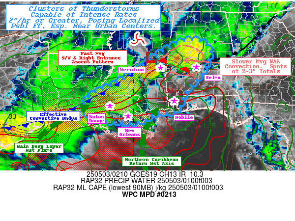
SUMMARY...A few clusters of stronger thunderstorms with localized
storm mergers/interactions to increase localized spot totals to
2-3" and low-end possible flash flooding with increased potential
magnitude if intersecting larger urban areas.

DISCUSSION...GOES-E WV suite shows broad, strong southwesterly
upper-level flow across Texas into the Southeast and eastern Ohio
Valley along/ahead of stron closed low in the Central Plains.
Embedded within it are a few stronger southern stream shortwave
features enhanced/maintained by right entrance jet ascent
patterns.  One in particular exists across north-central MS moving
quickly northeast; it is within the wake of another exiting across
the Cumberland Plateau.  This has resulted in low level convective
activity to have bowed out eastward across N AL now starting to
move quickly across N GA into the southern Appalachians.  The tail
end, under influence of the MS wave has angled back westward and
is acting as an effective warm front from pre-frontal
southwesterly flow and strengthening warm advection regime.  As
such, increased istentropic ascent of moderately unstable and
moist air denoted by 1500 MLCAPE and 1.25-1.5" slug of enhanced
moisture.  As such a cluster of enhanced cooling tops can be seen
over west-central AL.  This cluster is slowly propagating eastward
in a col in steering flow. This is likely to increase duration and
storm scale interaction/mergers over the next few hours.  With
occasional rates of 1.5-1.75", localized totals of 2-3" are
probable and may result in localized FF given the locally lower
FFG values in the area.

Southwestward across southern MS/LA... the fast moving shortwave
across central MS has been resulting in increased height-falls and
southeastward propagation of the active convective/effective
pre-frontal convergence line.  New activity continues to grow and
cool within 10.3um GOES-E IR loop from eastern MS back to central
LA where orientation once again begins to be more flat,
east-northeast to west-southwest.  Still, strong convergence and
increased deep layer moisture up to 1.75" may allow for very
intense downdrafts with spots of sub-hourly 1.5-2" as the line
advances southeastward.  FFG values are quite high and unless
these cells traverse the larger urban centers across I-10/12,
flash flooding will be less likely, but still non-zero through the
overnight period.

Of increasing interest is the MS and AL coastal counties, mainly
after 06z, but a few cells have already begun to develop in the
vicinity of far SE LA.  CIRA LPW, particularly in the sfc to 850mb
layer shows a narrow but strongly enhanced axis of moisture that
can be traces along the western edge of a recent sub-tropical
ridge as return flow from the Northern Caribbean tropical moisture
source.  This can be tracks through 850-700mb and totals are
1.5-1.7" with a recent uptick as the return flow becomes
convergent/confluent on the northwest edge of the sub-tropical
ridge axis.  This convergence into the southwesterly flow ahead of
the approaching trof, further taps the higher theta-E of the Gulf
too, with WAA development.  This is expected to expand/rapidly
develop near the diurnal peak of convection near 07-09z,
intersecting with the approaching line from the northwest.
Overall totals prior to 09z may not be significant, yet (likely
peaking after 09z) the start in proximity to the coastal urban
centers still may pose low end flash flooding and trends will be
watched closely for subsequent MPD(s).

Gallina

ATTN...WFO...BMX...JAN...LCH...LIX...MOB...

ATTN...RFC...LMRFC...SERFC...NWC...

LAT...LON   33648696 33388651 33028634 32018679 31268750
            30308795 30208896 29828951 29789068 29959182
            30379235 31029202 31529096 32178988 32938889
            33488795 33638745
Download in GIS format: Shapefile
| KML
Last Updated: 1026 PM EDT Fri May 02 2025
|


