| WPC Met Watch |
|
|
Mesoscale Precipitation Discussion: #0218 (2019) |
|
(Issued at 229 PM EDT Thu May 09 2019
) |
|
| MPD Selection |
|
|
|
|
|

Mesoscale Precipitation Discussion 0218
NWS Weather Prediction Center College Park MD
229 PM EDT Thu May 09 2019

Areas affected...Southern Louisiana, Far Southeast Texas

Concerning...Heavy rainfall...Flash flooding likely

Valid 091825Z - 092215Z

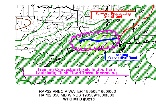
Summary...The threat of flash flooding is increasing across
southern Louisiana and far southeast Texas this afternoon.
Thunderstorms are likely to move slowly and repeatedly affect the
same areas. Hourly rainfall rates to around 2 inches are likely.

Discussion...Radar and satellite trends indicated that an
extensive QLCS was becoming segmented into two main portions: (1)
a forward propagating section across Alabama and southeast
Mississippi, and (2) a stalling segment in southern Louisiana. The
portion of the line over Louisiana should become a more
significant flash flood threat into the afternoon hours as
slow-moving thunderstorms continue to produce very heavy rain
rates over saturated soils. Recent radar VWP trends show veering
925-850mb winds in the past few hours (15-18Z) from KLCH back to
KHGX and THOU. The low-level winds were increasingly feeding into
the western edge of the convective band over Louisiana (a
configuration that favors backbuilding), and becoming aligned with
mid-upper level winds (which may favor training of existing
convection). Therefore, changes in the wind fields appear to be
substantially increasing the chances for focused swaths of heavy
rainfall. Estimated hourly rain rates on MRMS and KLCH/KLIX dual
pol are around 1-2 inches in most of the convective bands, and as
high as 3 inches in the areas of strongest convection. Flash
flooding will become more likely as rain rates of this magnitude
repeatedly affect certain locations for a couple hours, and
localized rainfall totals by 22Z may exceed 6 inches.

The 12Z HREF suggests the area most likely to receive heavy
rainfall between 18-22Z is from far SE TX into SW LA, roughly from
BMT-BTR, just north of I-10. This makes sense as it is near the
western edge of the current band of convection, which will be in
closest proximity to unobstructed low-level inflow in the next few
hours. Some places in this same corridor, especially from Acadia
to Beauregard Parishes, have already received 2-3 inches of rain
today, and another couple hours of additional heavy rain could
lead to more significant flash flooding in southwest Louisiana.

Lamers

ATTN...WFO...HGX...JAN...LCH...LIX...

ATTN...RFC...LMRFC...WGRFC...

LAT...LON   31329055 30729003 30049047 29869208 29789407
            30549459 31019356 31249180
Last Updated: 229 PM EDT Thu May 09 2019
|


