| WPC Met Watch |
|
|
Mesoscale Precipitation Discussion: #0222 |
|
(Issued at 830 PM EDT Sun May 04 2025
) |
|
| MPD Selection |
|
|
|
|
|

Mesoscale Precipitation Discussion 0222
NWS Weather Prediction Center College Park MD
830 PM EDT Sun May 04 2025

Areas affected...Central and Eastern NM...Portions of the Western
TX

Concerning...Heavy rainfall...Flash flooding possible

Valid 050030Z - 050630Z

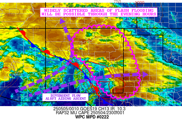
SUMMARY...Clusters of showers and thunderstorms will continue
through the evening hours across areas of central and eastern NM
and edging out into parts of western TX. Heavy rainfall rates will
continue to promote a concern for widely scattered areas of flash
flooding.

DISCUSSION...The late-day GOES-E IR satellite imagery shows
several broken clusters of heavy showers and thunderstorms with
cold convective tops impacting areas central and eastern NM into
parts of far western TX.

There continues to be as much as 1000+ J/kg of MUCAPE pooled
across much of central to southeast NM which coupled with
relatively moist low-level southeast flow should tend to maintain
the convective threat well through the evening hours. Divergent
flow aloft associated with left-exit region upper-level jet
dynamics downstream of an upper trough/closed low over the
Southwest is also yielding a corridor of deeper layer ascent for
more sustainable clusters of convection.

Rainfall rates with the stronger convective cells should continue
to be on the order of 1 to 1.5 inches/hour over the next several
hours, with some localized orographic ascent/upslope flow over the
higher terrain favoring some of these higher rates.

A combination of some cell-mergers and cell-training may foster
some storm total amounts of as much as 2 to 4 inches which is
generally favored by a consensus of the latest hires model
guidance. This may result in some additional widely scattered
areas of flash flooding which may occur near some locally
sensitive burn scar locations or dry washes.

Orrison

ATTN...WFO...ABQ...AMA...LUB...MAF...PUB...

ATTN...RFC...ABRFC...WGRFC...NWC...

LAT...LON   37110471 36770348 35520268 33950207 32790196
            31890254 31730357 32220446 32920496 34270577
            35150681 36220683 36870611
Download in GIS format: Shapefile
| KML
Last Updated: 830 PM EDT Sun May 04 2025
|


