| WPC Met Watch |
|
|
Mesoscale Precipitation Discussion: #0230 |
|
(Issued at 155 AM EDT Tue May 06 2025
) |
|
| MPD Selection |
|
|
|
|
|

Mesoscale Precipitation Discussion 0230
NWS Weather Prediction Center College Park MD
155 AM EDT Tue May 06 2025

Areas affected...Central PA...West Central Upstate NY...

Concerning...Heavy rainfall...Flash flooding possible

Valid 060555Z - 061100Z

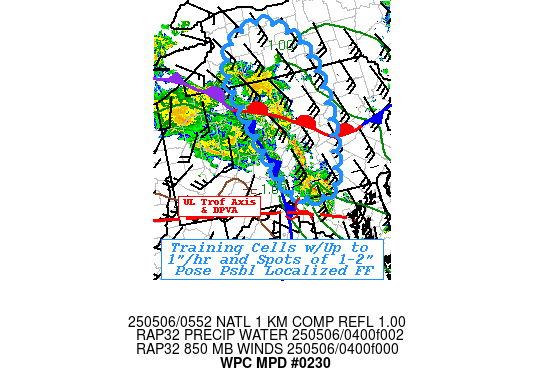
SUMMARY...Additional 1-2" of rainfall in 1-2 hours across recently
saturated soils and low FFG pose possible localized flash flooding
over next few

DISCUSSION...GOES-E WV shows an eastward extension of the deep
upper low, extending across WV into central MD providing increased
downstream DPVA ascent and a localized increase in low level WAA
across MD into central PA.   05z surface analysis shows the cold
front remains fairly banked up along the front range/Blue Ridge of
the Appalachians into central PA connecting to a triple point
south of BFD, with warm front bisecting PA just north of SEG
toward the Lehigh Valley.  Along with the slight increase in LLJ
to 30kts, increased low level moisture is bringing back 1.0-1.25"
total PWats and some weak instability about 250-500 J/kg.  Solid
southwesterly flow along/behind the cold front further strengthens
FGEN ascent through the area.   As such, recent RADAR and 10.3um
EIR show increasing shallow convective cells across the
Mason-Dixon line from RSP to DMW, but extend northward through
much of the warm sector in central PA.

Deep layer steering along/ahead of the cold front will support
training of cells; with 1"/hr rates, so with length supportive of
1-2 hours of training across a narrow axis.  This may result in an
additional 1-2" in less than 2hrs across areas that already had
some heavy rainfall this afternoon, especially further north into
south-central NY.  The combination over saturated ground
conditions and 1-3hr FFG values of .5-1.25 and .75 to 2,
respectivly; suggest flash flooding may be possible through the
remainder of the overnight period.

Gallina

ATTN...WFO...BGM...BUF...CTP...

ATTN...RFC...MARFC...NERFC...OHRFC...NWC...

LAT...LON   42997787 42947738 42617691 42077658 41467649
            40697655 40457662 39757688 39907774 41387840
            42187861 42717843
Download in GIS format: Shapefile
| KML
Last Updated: 155 AM EDT Tue May 06 2025
|


