| WPC Met Watch |
|
|
Mesoscale Precipitation Discussion: #0231 |
|
(Issued at 400 AM EDT Tue May 06 2025
) |
|
| MPD Selection |
|
|
|
|
|

Mesoscale Precipitation Discussion 0231
NWS Weather Prediction Center College Park MD
400 AM EDT Tue May 06 2025

Areas affected...TX Big Country through Hill Country...Adj Ext
Southweset OK...

Concerning...Heavy rainfall...Flash flooding possible

Valid 060800Z - 061400Z

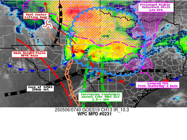
SUMMARY...Broad area of ascent across much of TX ahead of
anomalously deep closed low exiting the Southwest.  Scattered
incidents of flash flooding possible with localized 2-3" totals
across recently saturated grounds/low FFG.

DISCUSSION...GOES-E WV shows core of 3-3.5 Std Dev. closed low is
finally starting to translate eastward given upstream kicker
resulting in very broad downstream diffluence/divergence area to
shift out of the High Plains into the Big Country and eastern
Edwards Plateau.  A convectively reinforced shortwave is starting
to shear along the northeast quadrant of the low and pivot into E
NM still providing an axis of 700mb isentropic ascent/WAA channel
to maintain elevated convection/broadening moderate shield
precipitation across the Rolling Plains into the Big Country and
Red River Valley.  Activity is scattered and generally lighter
with occasional embedded cores capable of 1"+/hr rates but
increased duration over greatest saturated soil conditions (where
precip anomalies are 300-500% of normal and remain in the upper
90th percentiles of saturation).  As such, limited infiltration
will result in some enhanced run-off, but likely be limited in
coverage to those random/scattered elevated cores.

Southward into the Edwards Plateau/Hill Country...
A broad/strong axis of DPVA ahead of the main height-falls is
maintaining the 999mb low near/south of MAF, the stationary front
is starting to lift northeast as a warm front ahead of the low and
the dry line across the Western TX Panhandle is shifting eastward
increasing moisture convergence ahead of it.  Warm moist winds out
of the Rio Grande Valley continue to advect 1.3-1.5" total PWats
(loaded mainly below 850mb) will continue to be highly confluent
even as they veer more southerly/southwesterly over the next few
hours.  Higher unstable air with MUCAPE of 2000+ j/kg will
isentropically ascend across the front and maintain stronger
thunderstorms/clusters along the boundary as they shift eastward.
Rates of 2"/hr are probable, though 1.5" may fall in 15-30 minutes
given 06z HRRR forecast and given some upstream cells may allow
for two rounds and/or flanking line repeating/training resulting
in spots of  2-3.5" totals mainly near/just north of the front
across the Edwards Plateau toward the Hill country.  This area has
experienced less heavy rainfall than further north, so soil ratios
are much more supportive of infiltration, but the shear intense
rates have a solid probability to result in scattered incidents of
flash flooding through daybreak.

Gallina

ATTN...WFO...EWX...FWD...LUB...MAF...OUN...SJT...

ATTN...RFC...ABRFC...WGRFC...NWC...

LAT...LON   34689941 34119755 32869680 31409681 31019684
            30319715 29989767 29939885 30480069 30920171
            31550195 32830212 34090165 34610071
Download in GIS format: Shapefile
| KML
Last Updated: 400 AM EDT Tue May 06 2025
|


