| WPC Met Watch |
|
|
Mesoscale Precipitation Discussion: #0236 |
|
(Issued at 126 AM EDT Tue May 07 2024
) |
|
| MPD Selection |
|
|
|
|
|

Mesoscale Precipitation Discussion 0236
NWS Weather Prediction Center College Park MD
126 AM EDT Tue May 07 2024

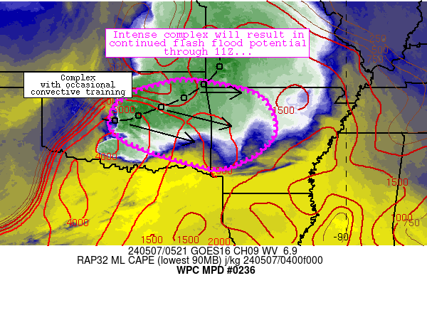
Areas affected...central/eastern Oklahoma into western Arkansas

Concerning...Heavy rainfall...Flash flooding likely

Valid 070525Z - 071125Z

Summary...An intense MCS continues to promote training
thunderstorms while moving east-southeastward across
central/eastern Oklahoma.  Flash flooding is likely in a few
locales as this complex moves toward west-central Arkansas through
11Z.

Discussion...An environmental parameter space characterized by
large buoyancy (3000+ J/kg MLCAPE), strong shear (500+ m2/s2 0-3km
SRH), and moisture (1.5 inch PW values) continues to support
robust, efficient convection responsible for areas of 2-3 inch/hr
rain rates at times especially just east of Oklahoma City near
Stroud.  The rates are materializing amid training convection (in
a WNW-ESE fashion) despite relatively quick movement of
individiual cells within the MCS.  These rates were also exceeding
both 1-hour (1.5 inch) and 3-hour (2.5) inch thresholds, while
also promoting spots of moderate MRMS Flash responses in addition
to areas of water over roads across central Oklahoma.

Despite relatively quick movement, the orientation of storms,
continued strong low-level shear (with 50-kt southerly low-level
flow oriented perpendicular to convection) and the aforementioned
favorable environment will continue to support east to
east-southeast movement of convection across east-central OK and
into west-central Arkansas through 11Z.  Areas of 2-3 inch/hr rain
rates are also expected where training is pronounced, which should
continue to result in occasional flash flood occurrences.  It is
worth noting that the weakening trend in models (CAMs in
particular) may be too quick, and training storms could persist
into western Arkansas through 11Z.

Cook

ATTN...WFO...LZK...OUN...SGF...SHV...TSA...

ATTN...RFC...ABRFC...LMRFC...NWC...

LAT...LON   36729533 36509377 36139278 35319236 34689258
            34049354 33889453 34579685 35119767 35609770
            36019744 36449667
Download in GIS format: Shapefile
| KML
Last Updated: 126 AM EDT Tue May 07 2024
|


