| WPC Met Watch |
|
|
Mesoscale Precipitation Discussion: #0237 |
|
(Issued at 724 PM EDT Tue May 06 2025
) |
|
| MPD Selection |
|
|
|
|
|

Mesoscale Precipitation Discussion 0237
NWS Weather Prediction Center College Park MD
724 PM EDT Tue May 06 2025

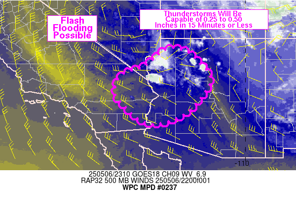
Areas affected...eastern CA, southern NV, western AZ

Concerning...Heavy rainfall...Flash flooding possible

Valid 062323Z - 070500Z

SUMMARY...An increasing coverage of thunderstorms across portions
of eastern CA, southern NV and western AZ over the next 2-4 hours
will be capable of flash flooding. Rainfall of 0.25 to 0.50 inches
in 15 minutes and storm totals of 1-2 inches are expected on a
spotty basis.

DISCUSSION...GOES West water vapor imagery placed a closed
mid-level low over south-central NV at 23Z, advancing slowly to
the south. The approach of this low and its southern elongation
into CA has allowed low level winds to shift from a northerly
direction this morning to southwesterly to its south, increasing
low level theta-e values into the lower Colorado River Valley. The
combination of surface heating and low level moisture advection
has increased MLCAPE values into the 500-1000 J/kg range from
southern NV into eastern CA and western AZ via the 23Z SPC
mesoanalysis. Visible satellite and radar imagery showed a few
thunderstorms along the NV/AZ border, co-located with severe and
flash flood warnings. Visible satellite imagery also showed
developing cumulus over eastern CA with a few early thunderstorms
over the Mojave Desert.

Continued low level moisture advection into eastern CA and western
AZ is expected to allow for marginal increases in an already
highly anomalous moisture axis (standardized PW anomalies of +3 to
+4). Mean westerly deeper layer flow of roughly 10 kt from the
west will be co-located with similarly oriented and slightly
stronger 700 mb winds which will be likely to support repeating
cells and brief upwind propagation of cells. Rainfall rates within
this environment should be easily capable of producing 0.25 to
0.50 inches of rain in 15 minutes or less, which could result in
some flash flooding of low lying areas and normally dry washes.
Storm total rainfall of 1 to 2 inches is expected through 05Z.

Otto

ATTN...WFO...FGZ...PSR...VEF...

ATTN...RFC...CBRFC...CNRFC...NWC...

LAT...LON   36511331 36321268 35751210 35141165 34561186
            33541272 33011382 33031480 33761571 34501618
            35261582 35671479 36481378
Download in GIS format: Shapefile
| KML
Last Updated: 724 PM EDT Tue May 06 2025
|


