| WPC Met Watch |
|
|
Mesoscale Precipitation Discussion: #0238 |
|
(Issued at 911 PM EDT Tue May 06 2025
) |
|
| MPD Selection |
|
|
|
|
|

Mesoscale Precipitation Discussion 0238
NWS Weather Prediction Center College Park MD
911 PM EDT Tue May 06 2025

Areas affected...southeastern TX into LA and central/southern MS

Concerning...Heavy rainfall...Flash flooding likely

Valid 070110Z - 070700Z

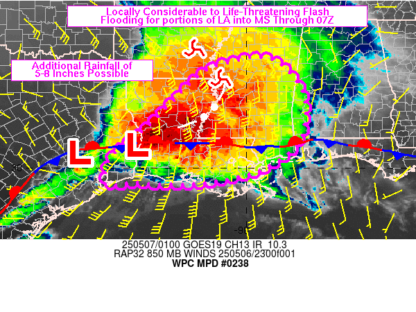
SUMMARY...Areas of heavy rain will continue a significant flash
flood threat across portions of south-central LA into MS through
07Z. Hourly rainfall in excess of 3 inches will be possible along
with additional rainfall of 5 to 8 inches. These higher end
rainfall totals could result in life-threatening conditions.

DISCUSSION...Radar mosaic imagery at 0045Z depicted widespread
thunderstorm coverage from western MS into central and southern
LA, with a narrow tail of thunderstorms extending into the TX
Coastal Plain. A weakening bowing segment was observed to be
crossing into western LA with warming cloud tops over the past
hour while a persistent area of cooling cloud tops has been
observed from near JAS (far southeastern TX) to near and south of
AEX (south-central LA), co-located with the low level overrunning
via ~50 kt of 850 mb flow. The region from Newton County to
Beauregard Parish has experienced hourly rainfall in excess of 3
inches since 21Z and has MRMS-derived rainfall of 4-6 inches over
the past 3 hours ending 00Z.

As a pair of convectively induced mesoscale circulations, located
on either side of the southern AR/MS border, advance toward the
northeast within the 700-500 mb flow, the axis of strongest 850 mb
flow will slowly advance east toward the LA/MS border through 06Z.
While some weakening of the low level flow is anticipated, the
northern portion of the convective cluster should advance into MS,
while the southwestern flank will be slower to advance downstream,
being met by developing thunderstorms atop the front and
rain-cooled air over southern/southwestern LA. Training of heavy
rainfall axes will continue to be capable of hourly rainfall in
excess of 3 inches beneath a strongly diffluent flow pattern
aloft.

23Z and 00Z WoFS guidance showed a small region of 40 to 70+
percent probabilities of 5+ inches over portions of south-central
LA into southwestern MS over their 6-hr forecast range. Using the
90th percentile output as a reasonable localized high-end of
additional rainfall potential, 7 to 8 inches could fall over
portions of south-central LA into southwestern MS. These rains
could result in locally considerable to life-threatening flash
flooding through 07Z.

Otto

ATTN...WFO...BMX...HGX...JAN...LCH...LIX...MOB...SHV...

ATTN...RFC...LMRFC...SERFC...WGRFC...NWC...

LAT...LON   33678915 32628814 31348806 30648844 29938955
            29529136 29479306 29539384 29429464 29759479
            30529442 31439328 33139156 33569059
Download in GIS format: Shapefile
| KML
Last Updated: 911 PM EDT Tue May 06 2025
|


